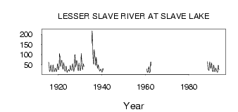
| PointID: | 675 | Code: | 07BK001 | Latitude (decimal degrees): | 55.30 | Longitude (decimal degrees): | -114.75 | Drainage Area (km2): | 13600.00 | Source: | Hydat | Hydrological Zone: | Mackenzie | Name: | LESSER SLAVE RIVER AT SLAVE LAKE |
|---|
| Download | |
|---|---|
| Site Descriptor Information | Site Time Series Data |
| Link to all available data | |
| ID | Year | Jan | Feb | Mar | Apr | May | Jun | Jul | Aug | Sep | Oct | Nov | Dec |
|---|---|---|---|---|---|---|---|---|---|---|---|---|---|
| 675 | 1915 | 62.30 | 61.80 | 58.50 | 50.10 | 43.00 | 26.00 | 18.00 | |||||
| 675 | 1916 | 17.00 | 20.00 | 22.00 | 30.00 | 39.20 | 44.60 | 49.20 | 46.20 | 36.50 | 30.60 | 26.00 | 20.00 |
| 675 | 1917 | 17.00 | 17.00 | 15.00 | 22.00 | 33.30 | 47.50 | 49.10 | 44.90 | 38.70 | 36.70 | 31.00 | 16.00 |
| 675 | 1918 | 19.00 | 16.00 | 18.00 | 18.00 | 25.50 | 28.10 | 30.40 | 33.30 | 31.00 | 29.80 | 23.00 | 17.00 |
| 675 | 1919 | 18.00 | 17.00 | 17.00 | 19.00 | 24.60 | 36.70 | 54.10 | 55.30 | 45.10 | 40.70 | 30.00 | 29.00 |
| 675 | 1920 | 27.00 | 26.00 | 27.00 | 30.00 | 42.90 | 75.70 | 106.00 | 99.10 | 91.90 | 89.60 | 68.00 | 44.00 |
| 675 | 1921 | 42.00 | 52.00 | 56.00 | 58.00 | 63.10 | 68.30 | 73.00 | 73.00 | 64.30 | 50.40 | 37.00 | 41.00 |
| 675 | 1922 | 29.00 | 28.00 | 32.00 | 36.00 | 54.50 | 60.50 | 51.40 | 51.70 | 42.90 | 37.60 | 29.00 | 21.00 |
| 675 | 1923 | 19.00 | 19.00 | 21.00 | 25.00 | 33.00 | 39.30 | 43.60 | 41.60 | 34.30 | 27.10 | 23.00 | 16.00 |
| 675 | 1924 | 12.00 | 18.00 | 20.00 | 20.00 | 20.70 | 21.80 | 22.50 | 24.70 | 27.90 | 26.00 | 23.00 | 21.00 |
| 675 | 1925 | 19.00 | 18.00 | 21.00 | 26.00 | 39.80 | 47.10 | 44.10 | 38.10 | 35.30 | 30.00 | 27.00 | 24.00 |
| 675 | 1926 | 24.00 | 24.00 | 23.00 | 24.00 | 33.50 | 53.40 | 55.70 | 43.80 | 40.90 | 42.00 | 37.00 | 28.00 |
| 675 | 1927 | 20.00 | 17.00 | 23.00 | 29.00 | 39.40 | 55.00 | 95.90 | 101.00 | 89.60 | 81.00 | 52.00 | 37.00 |
| 675 | 1928 | 43.00 | 51.00 | 57.00 | 60.00 | 67.70 | 71.50 | 70.40 | 61.80 | 52.30 | 46.70 | 33.00 | 27.00 |
| 675 | 1929 | 24.00 | 21.00 | 21.00 | 25.00 | 44.80 | 59.70 | 50.10 | 48.40 | 46.20 | 44.30 | 35.00 | 22.00 |
| 675 | 1930 | 23.00 | 22.00 | 22.00 | 34.00 | 49.30 | 88.30 | 106.00 | 92.30 | 80.50 | 68.60 | 56.00 | 49.00 |
| 675 | 1931 | 34.00 | 26.00 | 39.00 | 42.00 | 41.10 | 49.50 | 55.10 | 49.40 | 46.70 | 41.40 | ||
| 675 | 1935 | 156.00 | 219.00 | 214.00 | 183.00 | 140.00 | 94.00 | 79.00 | |||||
| 675 | 1936 | 69.00 | 61.00 | 54.00 | 53.00 | 96.80 | 112.00 | 125.00 | 116.00 | 105.00 | 101.00 | 91.00 | 81.00 |
| 675 | 1937 | 55.00 | 48.00 | 47.00 | 65.00 | 81.30 | 88.20 | 78.30 | 70.70 | 67.70 | 56.90 | 47.00 | 38.00 |
| 675 | 1938 | 33.00 | 33.00 | 45.00 | 49.00 | 49.80 | 43.70 | 40.00 | 34.10 | 30.10 | 26.90 | 23.00 | 22.00 |
| 675 | 1939 | 19.00 | 19.00 | 21.00 | 25.00 | 28.70 | 28.70 | 27.70 | 24.50 | 21.50 | 20.00 | 21.00 | 21.00 |
| 675 | 1940 | 14.00 | 13.00 | 16.00 | 19.00 | 25.90 | 31.80 | 30.30 | 27.60 | 22.40 | |||
| 675 | 1960 | 29.60 | 26.70 | 22.10 | 15.00 | 13.00 | |||||||
| 675 | 1961 | 15.00 | 13.00 | 14.00 | 18.00 | 23.00 | 34.80 | 31.70 | 41.10 | 35.50 | 32.80 | 10.00 | 13.00 |
| 675 | 1962 | 13.00 | 14.00 | 14.00 | 17.00 | 39.40 | 63.10 | 63.40 | 57.10 | 44.90 | |||
| 675 | 1988 | 34.60 | 66.00 | 55.70 | 41.90 | 32.00 | 29.00 | ||||||
| 675 | 1989 | 26.00 | 24.00 | 23.00 | 23.00 | 33.80 | 48.80 | 53.10 | 64.50 | 61.80 | 53.60 | 43.00 | 42.00 |
| 675 | 1990 | 39.00 | 36.00 | 32.00 | 34.00 | 44.20 | 55.90 | 59.40 | 47.60 | 39.00 | 29.00 | 19.00 | 20.00 |
| 675 | 1991 | 19.00 | 17.00 | 16.00 | 18.00 | 32.80 | 46.30 | 48.30 | 38.10 | 30.60 | 22.20 | 17.00 | 17.00 |
| 675 | 1992 | 17.00 | 16.00 | 19.00 | 23.00 | 29.70 | 34.20 | 32.80 | 25.90 | 24.30 | 21.70 | 17.00 | 16.00 |
| 675 | 1993 | 15.00 | 13.00 | 13.00 | 14.00 | 21.80 | 25.00 | 46.30 | 48.60 | 44.80 | 36.00 | 28.00 | 26.00 |
| Other Close Sites | ||||||
|---|---|---|---|---|---|---|
| PointID | Latitude | Longitude | Drainage Area | Source | Name | |
| 680 | 55.29 | -114.59 | 14400.00 | Hydat | LESSER SLAVE RIVER AT HIGHWAY NO. 2A | |
 Return to R-Arctic Net Home Page