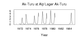
| PointID: | 6696 | Code: | 10093 | Latitude (decimal degrees): | 50.08 | Longitude (decimal degrees): | 87.82 | Drainage Area (km2): | 33.40 | Source: | SHI | Hydrological Zone: | Ob | Name: | Ak-Turu at Alp'Lager Ak-Turu |
|---|
| Download | |
|---|---|
| Site Descriptor Information | Site Time Series Data |
| Link to all available data | |
| ID | Year | Jan | Feb | Mar | Apr | May | Jun | Jul | Aug | Sep | Oct | Nov | Dec |
|---|---|---|---|---|---|---|---|---|---|---|---|---|---|
| 6696 | 1971 | 0.20 | 0.11 | 0.28 | 0.18 | 0.11 | |||||||
| 6696 | 1972 | 0.10 | 0.11 | 0.08 | 0.15 | 0.72 | 1.97 | 2.47 | 0.92 | 0.40 | 0.29 | 0.26 | 0.11 |
| 6696 | 1973 | 0.09 | 0.08 | 0.12 | 0.13 | 0.48 | 3.81 | 3.60 | 2.42 | 0.86 | 0.29 | 0.22 | 0.21 |
| 6696 | 1975 | 0.21 | 0.14 | 0.16 | 0.16 | 0.24 | 1.40 | 3.28 | 2.03 | 0.79 | 0.39 | 0.24 | 0.28 |
| 6696 | 1976 | 0.19 | 0.14 | 0.13 | 0.15 | 0.92 | 3.02 | 4.33 | 2.94 | ||||
| 6696 | 1977 | 0.12 | 0.48 | 2.50 | 4.91 | 3.06 | 1.24 | 0.63 | 0.35 | 0.26 | |||
| 6696 | 1978 | 0.21 | 0.20 | 0.21 | 0.24 | 0.30 | 2.28 | 4.25 | 2.08 | ||||
| 6696 | 1979 | 0.24 | 0.13 | 0.09 | 0.12 | 0.61 | 2.69 | 5.33 | 2.75 | 1.02 | 0.66 | 0.28 | 0.23 |
| 6696 | 1980 | 0.25 | 0.23 | 0.20 | 0.20 | 1.13 | 2.06 | 4.32 | 2.60 | ||||
| 6696 | 1984 | 0.19 | 0.19 | 0.13 | 0.12 | 0.56 | 1.35 | 3.48 | 4.36 | 1.48 | 0.39 | 0.17 | 0.17 |
 Return to R-Arctic Net Home Page