Ak-Alaha at Bertek
Ob
| PointID: | 6691 |
Code: | 10081 |
Latitude (decimal degrees): | 49.30 |
Longitude (decimal degrees): | 87.62 |
Drainage Area (km2): | 602.00 |
Source: | SHI |
Hydrological Zone: | Ob |
Name: | Ak-Alaha at Bertek |
Field Definitions
Site Time Series Plot:
Site Data File:
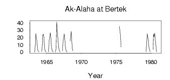
(Units: m3/s)
| ID | Year | Jan | Feb | Mar | Apr | May | Jun | Jul | Aug | Sep | Oct | Nov | Dec |
|---|
| 6691 | 1963 | | | | 0.01 | 8.06 | 25.40 | 19.00 | 15.60 | 3.69 | 1.38 | 0.63 | 0.40 |
| 6691 | 1964 | | | | 0.68 | 7.29 | 23.00 | 24.60 | 20.30 | 5.17 | 1.85 | 0.69 | 0.14 |
| 6691 | 1965 | | | | 0.01 | 15.20 | 20.50 | 26.50 | 18.40 | 8.37 | 2.41 | 1.02 | 0.25 |
| 6691 | 1966 | | | | 0.07 | 5.75 | 41.30 | 27.50 | 20.40 | 10.10 | 3.52 | 0.96 | 0.18 |
| 6691 | 1967 | | | | 1.51 | 16.80 | 18.30 | 24.90 | 17.40 | 6.90 | 2.46 | 0.80 | 0.02 |
| 6691 | 1968 | | | | | 15.00 | 18.70 | 28.40 | 14.90 | 4.76 | 1.74 | | |
| 6691 | 1975 | | | | | | 35.20 | 28.20 | 22.50 | 6.96 | | | |
| 6691 | 1979 | | | | 0.43 | 11.70 | 25.10 | 20.70 | 17.20 | 6.24 | 3.27 | 0.46 | |
| 6691 | 1980 | | | | 3.33 | 25.00 | 20.80 | 25.80 | 15.90 | 8.66 | 0.15 | | |
 Return to R-Arctic Net Home Page