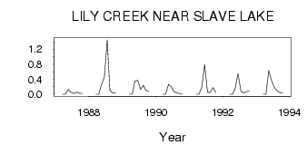
| PointID: | 669 | Code: | 07BG004 | Latitude (decimal degrees): | 55.41 | Longitude (decimal degrees): | -114.81 | Drainage Area (km2): | 23.79 | Source: | Hydat | Hydrological Zone: | Mackenzie | Name: | LILY CREEK NEAR SLAVE LAKE |
|---|
| Download | |
|---|---|
| Site Descriptor Information | Site Time Series Data |
| Link to all available data | |
| ID | Year | Jan | Feb | Mar | Apr | May | Jun | Jul | Aug | Sep | Oct | Nov | Dec |
|---|---|---|---|---|---|---|---|---|---|---|---|---|---|
| 669 | 1987 | 0.00 | 0.00 | 0.13 | 0.06 | 0.02 | 0.06 | 0.03 | 0.02 | ||||
| 669 | 1988 | 0.00 | 0.00 | 0.26 | 0.46 | 1.45 | 0.12 | 0.03 | 0.04 | ||||
| 669 | 1989 | 0.00 | 0.00 | 0.35 | 0.37 | 0.13 | 0.24 | 0.10 | 0.08 | ||||
| 669 | 1990 | 0.00 | 0.00 | 0.26 | 0.21 | 0.07 | 0.04 | 0.02 | 0.02 | ||||
| 669 | 1991 | 0.00 | 0.00 | 0.19 | 0.79 | 0.06 | 0.04 | 0.18 | 0.05 | ||||
| 669 | 1992 | 0.00 | 0.00 | 0.15 | 0.55 | 0.09 | 0.03 | 0.07 | 0.08 | ||||
| 669 | 1993 | 0.00 | 0.00 | 0.63 | 0.38 | 0.19 | 0.09 | 0.05 | 0.03 |
 Return to R-Arctic Net Home Page