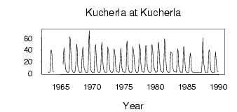
Kucherla at Kucherla
Ob
| PointID: | 6689 |
Code: | 10078 |
Latitude (decimal degrees): | 50.12 |
Longitude (decimal degrees): | 86.33 |
Drainage Area (km2): | 627.00 |
Source: | SHI |
Hydrological Zone: | Ob |
Name: | Kucherla at Kucherla |
Field Definitions
Site Time Series Plot:
Site Data File:
(Units: m3/s)
| ID | Year | Jan | Feb | Mar | Apr | May | Jun | Jul | Aug | Sep | Oct | Nov | Dec |
|---|
| 6689 | 1963 | 1.48 | 1.16 | 1.17 | 1.28 | 8.09 | 39.80 | 39.00 | 31.80 | 9.27 | 3.35 | 2.36 | 2.23 |
| 6689 | 1965 | | | | | 15.40 | 34.70 | 43.40 | 32.80 | 17.70 | 5.83 | 5.10 | 1.49 |
| 6689 | 1966 | 1.82 | 1.24 | 1.14 | 2.30 | 6.99 | 62.60 | 59.00 | 37.90 | 16.40 | 6.40 | 2.99 | 1.50 |
| 6689 | 1967 | 1.20 | 0.86 | 1.20 | 2.71 | 12.80 | 33.80 | 49.80 | 42.10 | 12.60 | 6.20 | 4.68 | 2.09 |
| 6689 | 1968 | 0.75 | 0.84 | 0.77 | 1.82 | 23.00 | 37.40 | 44.90 | 27.00 | 8.97 | 5.97 | 3.02 | 1.59 |
| 6689 | 1969 | 1.36 | 1.03 | 1.19 | 1.78 | 16.60 | 57.10 | 73.20 | 32.80 | 24.40 | 6.09 | 2.82 | 1.81 |
| 6689 | 1970 | 1.08 | 1.22 | 1.23 | 1.16 | 17.40 | 42.90 | 49.50 | 36.30 | 12.90 | 6.44 | 4.39 | 1.47 |
| 6689 | 1971 | 1.36 | 1.14 | 1.08 | 3.40 | 14.70 | 45.90 | 53.10 | 34.70 | 16.50 | 7.50 | 4.93 | 2.12 |
| 6689 | 1972 | 1.38 | 0.97 | 0.90 | 1.57 | 13.10 | 45.10 | 40.50 | 34.90 | 14.60 | 6.18 | 3.38 | 1.96 |
| 6689 | 1973 | 1.25 | 0.98 | 0.91 | 2.40 | 8.01 | 41.60 | 38.30 | 29.50 | 14.30 | 5.47 | 4.00 | 2.34 |
| 6689 | 1974 | 1.84 | 1.51 | 0.91 | 1.80 | 12.80 | 25.60 | 43.10 | 31.60 | 8.39 | 3.70 | 1.78 | 1.81 |
| 6689 | 1975 | 1.62 | 1.34 | 1.19 | 1.38 | 7.21 | 50.50 | 55.50 | 33.70 | 12.70 | 6.91 | 2.56 | 1.47 |
| 6689 | 1976 | 1.61 | 0.97 | 0.96 | 1.99 | 18.60 | 45.40 | 38.70 | 31.80 | 15.50 | 8.43 | 5.09 | 1.22 |
| 6689 | 1977 | 0.67 | 0.47 | 1.04 | 3.58 | 13.00 | 50.10 | 45.00 | 41.30 | 17.20 | 9.86 | 3.51 | 2.91 |
| 6689 | 1978 | 2.08 | 1.45 | 1.50 | 3.43 | 10.70 | 47.30 | 47.50 | 36.20 | 12.30 | 6.91 | 2.74 | 2.17 |
| 6689 | 1979 | 1.45 | 1.35 | 1.18 | 2.01 | 13.50 | 49.30 | 45.30 | 33.20 | 15.40 | 7.35 | 8.23 | 4.25 |
| 6689 | 1980 | 1.31 | 1.43 | 1.80 | 1.95 | 25.10 | 53.40 | 50.30 | 34.30 | 16.10 | 5.60 | 3.47 | 2.94 |
| 6689 | 1981 | 2.01 | 1.39 | 1.61 | 2.79 | 24.10 | 59.30 | 51.20 | 35.90 | 18.70 | 5.91 | 3.04 | 2.11 |
| 6689 | 1982 | 1.46 | 0.64 | 1.20 | 1.95 | 19.90 | 37.00 | 35.30 | 34.50 | 14.30 | 7.89 | 4.66 | 2.39 |
| 6689 | 1983 | 1.88 | 2.08 | 1.98 | 1.47 | 6.98 | 29.80 | 41.70 | 37.70 | 13.50 | 6.97 | 3.79 | 2.44 |
| 6689 | 1984 | 1.37 | 1.74 | 1.62 | 1.10 | 7.98 | 44.20 | 45.40 | 34.60 | 15.50 | 4.89 | 2.60 | 1.23 |
| 6689 | 1985 | 1.25 | 1.08 | 1.17 | 1.71 | 10.50 | 26.30 | 34.40 | 27.90 | 8.53 | 3.60 | 2.38 | 1.26 |
| 6689 | 1987 | 1.28 | 0.74 | 0.77 | 1.41 | 12.00 | 38.20 | 60.60 | 26.20 | 15.10 | 9.18 | 2.56 | 1.34 |
| 6689 | 1988 | 0.75 | 0.64 | 0.76 | 1.63 | 6.75 | 35.00 | 40.20 | 36.00 | 15.40 | 5.52 | 2.50 | 1.29 |
| 6689 | 1989 | 0.70 | 0.37 | 0.65 | 0.72 | 10.40 | 25.40 | 36.70 | 24.40 | 13.90 | 4.53 | 3.01 | 2.22 |
 Return to R-Arctic Net Home Page