Ob at Kazyum Mis - Yamo
Ob
| PointID: | 6667 |
Code: | 10036 |
Latitude (decimal degrees): | 64.67 |
Longitude (decimal degrees): | 65.63 |
Drainage Area (km2): | 2350000.00 |
Source: | SHI |
Hydrological Zone: | Ob |
Name: | Ob at Kazyum Mis - Yamo |
Field Definitions
Site Time Series Plot:
Site Data File:
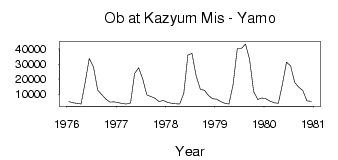
(Units: m3/s)
| ID | Year | Jan | Feb | Mar | Apr | May | Jun | Jul | Aug | Sep | Oct | Nov | Dec |
|---|
| 6667 | 1976 | 5140.00 | 4330.00 | 3870.00 | 3420.00 | 17800.00 | 33700.00 | 27800.00 | 12700.00 | 9620.00 | 6760.00 | 4780.00 | 4910.00 |
| 6667 | 1977 | 4380.00 | 3800.00 | 3480.00 | 4060.00 | 23800.00 | 27600.00 | 19900.00 | 9590.00 | 8390.00 | 7370.00 | 5140.00 | 5870.00 |
| 6667 | 1978 | 4620.00 | 3950.00 | 3560.00 | 3520.00 | 10600.00 | 36000.00 | 37100.00 | 22400.00 | 13200.00 | 12600.00 | 9010.00 | 6950.00 |
| 6667 | 1979 | 6650.00 | 5120.00 | 3950.00 | 3430.00 | 16000.00 | 40300.00 | 40300.00 | 43400.00 | 33100.00 | 11700.00 | 6560.00 | 7510.00 |
| 6667 | 1980 | 6930.00 | 5370.00 | 4280.00 | 3870.00 | 16700.00 | 31200.00 | 28800.00 | 17900.00 | 14700.00 | 12400.00 | 5510.00 | 5290.00 |
 Return to R-Arctic Net Home Page