Ob at Mogochin
Ob
| PointID: | 6663 |
Code: | 10020 |
Latitude (decimal degrees): | 57.72 |
Longitude (decimal degrees): | 83.55 |
Drainage Area (km2): | 482000.00 |
Source: | SHI |
Hydrological Zone: | Ob |
Name: | Ob at Mogochin |
Field Definitions
Site Time Series Plot:
Site Data File:
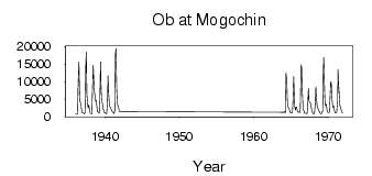
(Units: m3/s)
| ID | Year | Jan | Feb | Mar | Apr | May | Jun | Jul | Aug | Sep | Oct | Nov | Dec |
|---|
| 6663 | 1936 | 775.00 | 643.00 | 601.00 | 841.00 | 9340.00 | 15600.00 | 8160.00 | 4220.00 | 3760.00 | 2510.00 | 1210.00 | 1040.00 |
| 6663 | 1937 | 1120.00 | 951.00 | 801.00 | 1090.00 | 15300.00 | 18400.00 | 6520.00 | 3520.00 | 2470.00 | 3330.00 | 2110.00 | 1050.00 |
| 6663 | 1938 | 911.00 | 843.00 | 727.00 | 7020.00 | 14600.00 | 11100.00 | 7480.00 | 5590.00 | 4310.00 | 4670.00 | 2780.00 | 1340.00 |
| 6663 | 1939 | 1390.00 | 1130.00 | 962.00 | 4400.00 | 15600.00 | 7800.00 | 4980.00 | 3630.00 | 2360.00 | 1980.00 | 1110.00 | 1160.00 |
| 6663 | 1940 | 1060.00 | 807.00 | 764.00 | 4650.00 | 11700.00 | 7090.00 | 3890.00 | 2830.00 | 2750.00 | 2060.00 | 1780.00 | 1480.00 |
| 6663 | 1941 | 1250.00 | 1060.00 | 876.00 | 1780.00 | 17800.00 | 19500.00 | 7940.00 | 4340.00 | 3100.00 | 2710.00 | 1740.00 | 1460.00 |
| 6663 | 1964 | 1260.00 | 1460.00 | 1070.00 | 1090.00 | 12400.00 | 10200.00 | 4800.00 | 2830.00 | 2490.00 | 2280.00 | 1620.00 | 1100.00 |
| 6663 | 1965 | 1010.00 | 1040.00 | 1040.00 | 3820.00 | 11400.00 | 6850.00 | 2790.00 | 1800.00 | 2700.00 | 2720.00 | 1590.00 | 1210.00 |
| 6663 | 1966 | 1290.00 | 1210.00 | 1110.00 | 2230.00 | 14700.00 | 14200.00 | 8500.00 | 3250.00 | 1970.00 | 1620.00 | 962.00 | 918.00 |
| 6663 | 1967 | 932.00 | 855.00 | 883.00 | 3050.00 | 8090.00 | 4500.00 | 4190.00 | 3970.00 | 3400.00 | 2440.00 | 1490.00 | 987.00 |
| 6663 | 1968 | 851.00 | 797.00 | 1090.00 | 4140.00 | 8510.00 | 5210.00 | 2960.00 | 2740.00 | 2060.00 | 1770.00 | 1010.00 | 988.00 |
| 6663 | 1969 | 870.00 | 883.00 | 943.00 | 1730.00 | 13100.00 | 16900.00 | 7320.00 | 3540.00 | 3020.00 | 3520.00 | 1870.00 | 1400.00 |
| 6663 | 1970 | 1190.00 | 1100.00 | 1180.00 | 6000.00 | 9540.00 | 10000.00 | 5300.00 | 3450.00 | 2600.00 | 2980.00 | 1930.00 | 1220.00 |
| 6663 | 1971 | 991.00 | 989.00 | 1280.00 | 4120.00 | 13400.00 | 9400.00 | 5590.00 | 3180.00 | 2420.00 | 1910.00 | 1300.00 | 981.00 |
 Return to R-Arctic Net Home Page