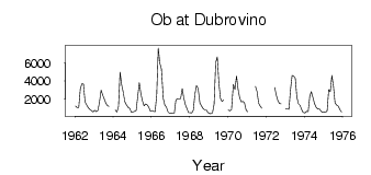
Ob at Dubrovino
Ob
| PointID: | 6662 |
Code: | 10015 |
Latitude (decimal degrees): | 55.48 |
Longitude (decimal degrees): | 83.28 |
Drainage Area (km2): | 258000.00 |
Source: | SHI |
Hydrological Zone: | Ob |
Name: | Ob at Dubrovino |
Field Definitions
Site Time Series Plot:
Site Data File:
(Units: m3/s)
| ID | Year | Jan | Feb | Mar | Apr | May | Jun | Jul | Aug | Sep | Oct | Nov | Dec |
|---|
| 6662 | 1962 | 1250.00 | 1070.00 | 1060.00 | 3110.00 | 3710.00 | 3660.00 | 1710.00 | 1390.00 | 1070.00 | 884.00 | 743.00 | 610.00 |
| 6662 | 1963 | 775.00 | 635.00 | 780.00 | 1720.00 | 3010.00 | 2440.00 | 2020.00 | 1570.00 | 1290.00 | 1210.00 | | |
| 6662 | 1964 | | 814.00 | 576.00 | 1210.00 | 4970.00 | 3580.00 | 2770.00 | 1730.00 | 1390.00 | 1100.00 | 988.00 | 547.00 |
| 6662 | 1965 | 607.00 | 664.00 | 745.00 | 2320.00 | 3810.00 | 2600.00 | 1810.00 | 1260.00 | 1460.00 | 1380.00 | 1140.00 | 694.00 |
| 6662 | 1966 | 740.00 | 659.00 | 648.00 | 2420.00 | 7620.00 | 5940.00 | 5300.00 | 2080.00 | 1320.00 | 1130.00 | 599.00 | 442.00 |
| 6662 | 1967 | 461.00 | 421.00 | 501.00 | 1920.00 | 2050.00 | 2010.00 | 2080.00 | 3170.00 | 2120.00 | 1400.00 | 945.00 | 526.00 |
| 6662 | 1968 | 525.00 | 486.00 | 795.00 | 2550.00 | 3480.00 | 3230.00 | 1600.00 | 1280.00 | 993.00 | 846.00 | 844.00 | 550.00 |
| 6662 | 1969 | 421.00 | 397.00 | 535.00 | 1470.00 | 6040.00 | 6660.00 | 3790.00 | 2110.00 | 1760.00 | 1910.00 | | |
| 6662 | 1970 | 820.00 | 730.00 | 880.00 | 3640.00 | 3100.00 | 4570.00 | 3090.00 | 2160.00 | 1690.00 | 1750.00 | 1610.00 | 861.00 |
| 6662 | 1971 | 609.00 | | | | | 3390.00 | 2820.00 | 1560.00 | 1250.00 | 1020.00 | | |
| 6662 | 1972 | | | | | | 3300.00 | 2440.00 | 1850.00 | 1530.00 | 1500.00 | | |
| 6662 | 1973 | 931.00 | 968.00 | 894.00 | 3070.00 | 4600.00 | 4520.00 | 4320.00 | 2230.00 | 1500.00 | 1320.00 | 910.00 | 537.00 |
| 6662 | 1974 | 496.00 | 679.00 | 626.00 | 2310.00 | 2830.00 | 2190.00 | 1540.00 | 1130.00 | 916.00 | 954.00 | 736.00 | 548.00 |
| 6662 | 1975 | 567.00 | 546.00 | 722.00 | 3050.00 | 2840.00 | 4610.00 | 3430.00 | 1580.00 | 1360.00 | 1250.00 | 832.00 | 570.00 |
 Return to R-Arctic Net Home Page