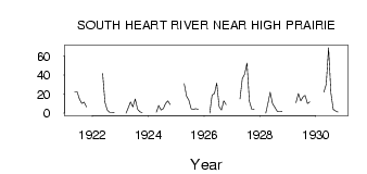
| PointID: | 666 | Code: | 07BF004 | Latitude (decimal degrees): | 55.53 | Longitude (decimal degrees): | -116.48 | Drainage Area (km2): | 4240.00 | Source: | Hydat | Hydrological Zone: | Mackenzie | Name: | SOUTH HEART RIVER NEAR HIGH PRAIRIE |
|---|
| Download | |
|---|---|
| Site Descriptor Information | Site Time Series Data |
| Link to all available data | |
| ID | Year | Jan | Feb | Mar | Apr | May | Jun | Jul | Aug | Sep | Oct | Nov | Dec |
|---|---|---|---|---|---|---|---|---|---|---|---|---|---|
| 666 | 1921 | 22.70 | 22.50 | 15.00 | 10.30 | 11.50 | 6.74 | ||||||
| 666 | 1922 | 41.80 | 11.20 | 3.22 | 0.78 | 0.83 | 0.71 | ||||||
| 666 | 1923 | 0.00 | 6.00 | 12.00 | 6.59 | 15.00 | 4.17 | 1.34 | 0.53 | ||||
| 666 | 1924 | 1.00 | 7.90 | 3.34 | 4.86 | 9.93 | 13.00 | 9.12 | |||||
| 666 | 1925 | 31.00 | 17.90 | 13.50 | 4.38 | 4.18 | 4.64 | 3.93 | |||||
| 666 | 1926 | 0.00 | 19.00 | 20.70 | 31.60 | 6.97 | 3.41 | 12.90 | 8.79 | ||||
| 666 | 1927 | 15.00 | 36.40 | 40.90 | 52.80 | 12.60 | 4.18 | 4.05 | |||||
| 666 | 1928 | 0.00 | 11.00 | 21.90 | 10.00 | 6.05 | 1.94 | 1.69 | 1.91 | ||||
| 666 | 1929 | 11.00 | 20.60 | 13.10 | 17.20 | 18.80 | 10.20 | 11.90 | |||||
| 666 | 1930 | 22.00 | 30.40 | 68.70 | 21.30 | 3.92 | 2.20 | 1.27 |
 Return to R-Arctic Net Home Page