Stolbovaya
Yenisei
| PointID: | 6653 |
Code: | 9538 |
Latitude (decimal degrees): | 62.10 |
Longitude (decimal degrees): | 91.33 |
Drainage Area (km2): | 5625.00 |
Source: | SHI |
Hydrological Zone: | Yenisei |
Name: | Stolbovaya |
Field Definitions
Site Time Series Plot:
Site Data File:
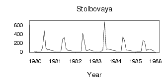
(Units: m3/s)
| ID | Year | Jan | Feb | Mar | Apr | May | Jun | Jul | Aug | Sep | Oct | Nov | Dec |
|---|
| 6653 | 1979 | | | | | | | | | | | | 14.30 |
| 6653 | 1980 | 14.60 | 15.20 | 15.30 | 15.60 | 88.80 | 476.00 | 83.50 | 44.60 | 55.80 | 37.70 | 27.70 | 20.60 |
| 6653 | 1981 | 15.90 | 14.80 | 15.10 | 17.00 | 283.00 | 321.00 | 77.10 | 34.10 | 31.60 | 25.50 | 15.80 | 15.50 |
| 6653 | 1982 | 15.30 | 15.10 | 14.90 | 17.60 | 418.00 | 222.00 | 32.30 | 34.40 | 53.60 | 35.30 | 25.30 | 19.10 |
| 6653 | 1983 | 18.20 | 17.10 | 15.00 | 12.60 | 42.00 | 674.00 | 56.10 | 69.20 | 58.80 | 51.20 | 37.70 | 29.80 |
| 6653 | 1984 | 20.40 | 19.70 | 20.90 | 20.90 | 336.00 | 256.00 | 48.90 | 36.20 | 31.10 | 24.70 | 19.60 | 19.80 |
| 6653 | 1985 | 16.70 | 14.20 | 13.80 | 15.40 | 250.00 | 237.00 | 33.70 | 54.10 | 63.40 | 50.60 | 25.70 | 18.90 |
 Return to R-Arctic Net Home Page