Derbina
Yenisei
| PointID: | 6652 |
Code: | 9536 |
Latitude (decimal degrees): | 55.27 |
Longitude (decimal degrees): | 92.67 |
Drainage Area (km2): | 1370.00 |
Source: | SHI |
Hydrological Zone: | Yenisei |
Name: | Derbina |
Field Definitions
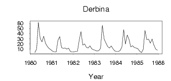
Site Time Series Plot:
Site Data File:
(Units: m3/s)
| ID | Year | Jan | Feb | Mar | Apr | May | Jun | Jul | Aug | Sep | Oct | Nov | Dec |
|---|
| 6652 | 1980 | | | 3.21 | 10.20 | 62.00 | 30.60 | 23.90 | 34.90 | 21.10 | 15.00 | 11.20 | 8.69 |
| 6652 | 1981 | 5.96 | 4.46 | 4.75 | 26.90 | 34.20 | 12.80 | 11.60 | 12.10 | 10.00 | 11.70 | 5.40 | 4.33 |
| 6652 | 1982 | 4.38 | 5.53 | 5.56 | 27.80 | 43.80 | 17.70 | 20.00 | 13.60 | 12.10 | 16.20 | 10.70 | 8.73 |
| 6652 | 1983 | 7.47 | 6.01 | 6.99 | 11.40 | 56.00 | 29.50 | 21.80 | 14.80 | 12.00 | 16.00 | 10.50 | 6.35 |
| 6652 | 1984 | 5.31 | 5.31 | 7.02 | 13.90 | 47.50 | 19.80 | 37.30 | 28.50 | 14.40 | 16.50 | 13.10 | 12.00 |
| 6652 | 1985 | 10.50 | 6.04 | 2.98 | 9.72 | 46.20 | 28.30 | 29.20 | 21.40 | 29.40 | 18.10 | 10.10 | 7.78 |
 Return to R-Arctic Net Home Page