Gorbiachin
Yenisei
| PointID: | 6641 |
Code: | 9498 |
Latitude (decimal degrees): | 67.48 |
Longitude (decimal degrees): | 87.83 |
Drainage Area (km2): | 3670.00 |
Source: | SHI |
Hydrological Zone: | Yenisei |
Name: | Gorbiachin |
Field Definitions
Site Time Series Plot:
Site Data File:
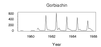
(Units: m3/s)
| ID | Year | Jan | Feb | Mar | Apr | May | Jun | Jul | Aug | Sep | Oct | Nov | Dec |
|---|
| 6641 | 1979 | 8.84 | 3.79 | 2.24 | 2.92 | | | | | | | 12.50 | |
| 6641 | 1980 | 9.27 | 7.76 | 6.11 | 4.80 | 4.02 | | | 41.70 | 86.40 | 39.40 | 12.00 | 8.25 |
| 6641 | 1981 | 7.59 | 6.47 | 5.29 | 5.60 | 5.88 | 539.00 | 85.30 | 22.30 | 34.60 | 20.80 | 12.60 | 10.70 |
| 6641 | 1982 | 9.61 | 7.87 | 5.81 | 7.00 | 56.10 | 621.00 | 36.40 | 39.70 | 93.20 | 31.60 | 14.00 | 9.09 |
| 6641 | 1983 | 7.03 | 3.80 | 3.81 | 2.54 | 3.03 | 495.00 | 55.70 | 67.30 | 43.90 | 31.70 | 15.60 | 6.41 |
| 6641 | 1984 | 6.39 | 5.13 | 5.23 | 3.52 | 31.30 | 461.00 | 32.30 | 30.00 | 47.70 | 16.40 | 8.24 | 9.07 |
| 6641 | 1985 | 7.75 | 5.19 | 4.74 | 6.23 | 27.70 | 354.00 | 62.60 | 76.60 | 68.80 | 37.50 | 18.50 | 11.50 |
 Return to R-Arctic Net Home Page