Kan at Kan-Okler
Yenisei
| PointID: | 6592 |
Code: | 9333 |
Latitude (decimal degrees): | 55.03 |
Longitude (decimal degrees): | 95.13 |
Drainage Area (km2): | 4180.00 |
Source: | SHI |
Hydrological Zone: | Yenisei |
Name: | Kan at Kan-Okler |
Field Definitions
Site Time Series Plot:
Site Data File:
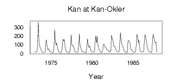
(Units: m3/s)
| ID | Year | Jan | Feb | Mar | Apr | May | Jun | Jul | Aug | Sep | Oct | Nov | Dec |
|---|
| 6592 | 1973 | 17.30 | 16.40 | 15.50 | 20.70 | 90.00 | 355.00 | 152.00 | 84.70 | 63.10 | 42.10 | 26.10 | 12.20 |
| 6592 | 1974 | 9.87 | 9.54 | 10.90 | 20.40 | 137.00 | 155.00 | 75.90 | 42.50 | 52.00 | 40.90 | 19.10 | 17.40 |
| 6592 | 1975 | 16.20 | 12.50 | 11.30 | 15.80 | 75.90 | 269.00 | 138.00 | 96.70 | 118.00 | 69.90 | 32.50 | 22.60 |
| 6592 | 1976 | 13.50 | 11.70 | 12.40 | 16.70 | 80.90 | 162.00 | 145.00 | 159.00 | 88.70 | 44.60 | 25.50 | 19.20 |
| 6592 | 1977 | 12.10 | 10.40 | 9.82 | 19.20 | 69.10 | 213.00 | 94.30 | 85.70 | 87.40 | 62.80 | 29.10 | 16.40 |
| 6592 | 1978 | 18.40 | 11.60 | 12.40 | 22.00 | 91.60 | 222.00 | 87.90 | 73.70 | 39.10 | 23.80 | 16.10 | 17.50 |
| 6592 | 1979 | 16.70 | 15.10 | 10.90 | 11.50 | 91.00 | 165.00 | 92.90 | 68.30 | 87.30 | 53.10 | 29.40 | 22.50 |
| 6592 | 1980 | 20.80 | 16.70 | 13.30 | 18.60 | 128.00 | 199.00 | 119.00 | 195.00 | 107.00 | 67.90 | 39.30 | 34.70 |
| 6592 | 1981 | 15.80 | 11.90 | 15.80 | 31.40 | 96.20 | 106.00 | 77.90 | 73.90 | 60.70 | 49.10 | 35.60 | 34.70 |
| 6592 | 1982 | 24.40 | 19.60 | 16.90 | 37.40 | 207.00 | 168.00 | 152.00 | 94.40 | 75.90 | 79.90 | 53.00 | 30.70 |
| 6592 | 1983 | 21.60 | 18.50 | 16.60 | 20.80 | 101.00 | 237.00 | 147.00 | 108.00 | 81.30 | 70.30 | 38.00 | 29.00 |
| 6592 | 1984 | 17.20 | 11.10 | 8.99 | 9.45 | 137.00 | 149.00 | 128.00 | 113.00 | 59.30 | 45.50 | 28.80 | 22.60 |
| 6592 | 1985 | 16.30 | 12.30 | 11.40 | 22.40 | 88.90 | 216.00 | 190.00 | 122.00 | 153.00 | 72.70 | 24.90 | 22.10 |
| 6592 | 1986 | 17.80 | 15.10 | 16.10 | 29.60 | 141.00 | 215.00 | 174.00 | 142.00 | 78.50 | 51.20 | 29.30 | 20.70 |
| 6592 | 1987 | 17.80 | 16.10 | 11.30 | 29.80 | 175.00 | 219.00 | 173.00 | 138.00 | 120.00 | 131.00 | 20.60 | 17.30 |
 Return to R-Arctic Net Home Page