| PointID: | 654 | Code: | 07BB903 | Latitude (decimal degrees): | 54.07 | Longitude (decimal degrees): | -114.90 | Drainage Area (km2): | 115.00 | Source: | Hydat | Hydrological Zone: | Mackenzie | Name: | ROMEO CREEK ABOVE ROMEO LAKE |
|---|
| Download | |
|---|---|
| Site Descriptor Information | Site Time Series Data |
| Link to all available data | |
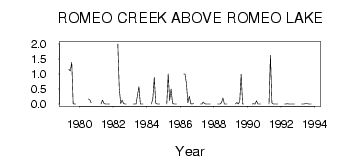
| ID | Year | Jan | Feb | Mar | Apr | May | Jun | Jul | Aug | Sep | Oct | Nov | Dec |
|---|---|---|---|---|---|---|---|---|---|---|---|---|---|
| 654 | 1979 | 1.16 | 1.10 | 1.39 | 0.01 | 5.0e-03 | 1.0e-03 | ||||||
| 654 | 1980 | 1.00 | 0.17 | 0.13 | 0.04 | ||||||||
| 654 | 1981 | 0.00 | 0.13 | 0.03 | 0.00 | 1.0e-03 | 0.00 | 0.00 | |||||
| 654 | 1982 | 2.00 | 0.53 | 0.02 | 0.13 | 0.02 | 0.00 | 0.00 | |||||
| 654 | 1983 | 0.00 | 0.00 | 3.0e-03 | 0.30 | 0.58 | 0.00 | 0.00 | 0.00 | ||||
| 654 | 1984 | 0.00 | 0.19 | 0.89 | 0.03 | 2.0e-03 | 2.0e-03 | 0.00 | |||||
| 654 | 1985 | 0.00 | 1.00 | 0.12 | 0.50 | 0.03 | 0.00 | 1.0e-03 | 0.00 | ||||
| 654 | 1986 | 1.00 | 1.00 | 0.68 | 0.04 | 0.26 | 0.01 | 3.0e-03 | 0.02 | ||||
| 654 | 1987 | 0.00 | 0.00 | 0.07 | 9.0e-03 | 0.00 | 0.00 | 0.00 | 0.00 | ||||
| 654 | 1988 | 0.00 | 0.00 | 1.0e-03 | 0.05 | 0.20 | 0.00 | 0.00 | 0.00 | ||||
| 654 | 1989 | 0.00 | 0.05 | 1.0e-03 | 0.08 | 0.99 | 2.0e-03 | 0.00 | |||||
| 654 | 1990 | 0.00 | 0.01 | 0.00 | 0.11 | 0.00 | 0.00 | 0.00 | |||||
| 654 | 1991 | 0.00 | 1.62 | 0.04 | 0.00 | 0.00 | 0.00 | 0.00 | |||||
| 654 | 1992 | 0.00 | 0.00 | 0.01 | 0.00 | 0.00 | 0.00 | 0.00 | 0.00 | ||||
| 654 | 1993 | 0.00 | 0.00 | 0.00 | 0.02 | 0.02 | 0.00 | 0.00 | 0.00 |
 Return to R-Arctic Net Home Page