Obusa
Yenisei
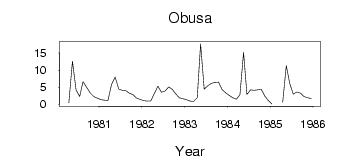
| PointID: | 6535 |
Code: | 8393 |
Latitude (decimal degrees): | 53.73 |
Longitude (decimal degrees): | 103.92 |
Drainage Area (km2): | 942.00 |
Source: | SHI |
Hydrological Zone: | Yenisei |
Name: | Obusa |
Field Definitions
Site Time Series Plot:
Site Data File:
(Units: m3/s)
| ID | Year | Jan | Feb | Mar | Apr | May | Jun | Jul | Aug | Sep | Oct | Nov | Dec |
|---|
| 6535 | 1980 | | | | 0.39 | 12.60 | 4.21 | 2.23 | 6.64 | 4.98 | 3.33 | 2.25 | 1.77 |
| 6535 | 1981 | 1.31 | 1.21 | 1.09 | 5.82 | 7.92 | 4.41 | 4.10 | 3.93 | 3.26 | 2.78 | 1.83 | 1.42 |
| 6535 | 1982 | 1.02 | 0.90 | 0.93 | 3.05 | 5.26 | 3.51 | 3.87 | 5.05 | 4.33 | 3.10 | 1.88 | 1.62 |
| 6535 | 1983 | 1.29 | 0.88 | 0.82 | 1.86 | 17.70 | 4.40 | 5.39 | 6.12 | 6.38 | 6.50 | 4.36 | 3.36 |
| 6535 | 1984 | 2.60 | 1.91 | 1.49 | 2.81 | 15.20 | 2.90 | 4.18 | 4.07 | 4.20 | 4.36 | 2.28 | 1.14 |
| 6535 | 1985 | 0.03 | | | 0.54 | 11.30 | 6.18 | 2.95 | 3.57 | 3.22 | 2.26 | 1.91 | 1.67 |
 Return to R-Arctic Net Home Page