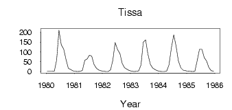
Tissa
Yenisei
| PointID: | 6534 |
Code: | 8391 |
Latitude (decimal degrees): | 52.47 |
Longitude (decimal degrees): | 99.65 |
Drainage Area (km2): | 2850.00 |
Source: | SHI |
Hydrological Zone: | Yenisei |
Name: | Tissa |
Field Definitions
Site Time Series Plot:
Site Data File:
(Units: m3/s)
| ID | Year | Jan | Feb | Mar | Apr | May | Jun | Jul | Aug | Sep | Oct | Nov | Dec |
|---|
| 6534 | 1980 | 2.16 | 1.71 | 1.69 | 2.56 | 59.40 | 210.00 | 136.00 | 114.00 | 61.50 | 17.00 | 10.80 | 4.61 |
| 6534 | 1981 | 2.26 | 1.32 | 1.68 | 6.48 | 57.70 | 64.80 | 83.80 | 78.60 | 36.50 | 17.30 | 8.92 | 4.53 |
| 6534 | 1982 | 2.67 | 1.43 | 1.29 | 9.74 | 56.60 | 148.00 | 111.00 | 91.80 | 42.00 | 20.00 | 12.80 | 6.01 |
| 6534 | 1983 | 2.75 | 1.41 | 2.09 | 4.60 | 33.70 | 150.00 | 161.00 | 88.90 | 36.90 | 18.70 | 10.90 | 4.93 |
| 6534 | 1984 | 1.99 | 0.80 | 1.12 | 3.68 | 34.10 | 123.00 | 186.00 | 130.00 | 54.40 | 19.70 | 7.79 | 5.24 |
| 6534 | 1985 | 2.32 | 1.67 | 1.32 | 2.14 | 55.40 | 113.00 | 113.00 | 70.90 | 54.80 | 20.70 | 5.52 | 2.55 |
 Return to R-Arctic Net Home Page