Zalari at Novokutski'
Yenisei
| PointID: | 6526 |
Code: | 8366 |
Latitude (decimal degrees): | 53.67 |
Longitude (decimal degrees): | 102.92 |
Drainage Area (km2): | 1470.00 |
Source: | SHI |
Hydrological Zone: | Yenisei |
Name: | Zalari at Novokutski' |
Field Definitions
Site Time Series Plot:
Site Data File:
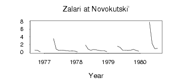
(Units: m3/s)
| ID | Year | Jan | Feb | Mar | Apr | May | Jun | Jul | Aug | Sep | Oct | Nov | Dec |
|---|
| 6526 | 1976 | | | | | | | | | 0.52 | 0.46 | 0.04 | |
| 6526 | 1977 | | | | 3.48 | 0.78 | 0.41 | 0.49 | 0.43 | 0.36 | 0.26 | 0.30 | 0.27 |
| 6526 | 1978 | 7.0e-03 | | | 1.83 | 0.77 | 0.45 | 0.68 | 0.57 | 0.42 | 0.35 | 0.37 | 0.10 |
| 6526 | 1979 | | | | 1.51 | 1.24 | 0.45 | 0.46 | 0.41 | 0.50 | 0.69 | 0.42 | 0.23 |
| 6526 | 1980 | | | | 7.84 | 2.25 | 0.88 | 0.96 | | | | | |
 Return to R-Arctic Net Home Page