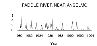
| PointID: | 652 | Code: | 07BB011 | Latitude (decimal degrees): | 53.85 | Longitude (decimal degrees): | -115.36 | Drainage Area (km2): | 261.00 | Source: | Hydat | Hydrological Zone: | Mackenzie | Name: | PADDLE RIVER NEAR ANSELMO |
|---|
| Download | |
|---|---|
| Site Descriptor Information | Site Time Series Data |
| Link to all available data | |
| ID | Year | Jan | Feb | Mar | Apr | May | Jun | Jul | Aug | Sep | Oct | Nov | Dec |
|---|---|---|---|---|---|---|---|---|---|---|---|---|---|
| 652 | 1980 | 0.00 | 2.00 | 0.76 | 7.15 | 1.35 | 1.10 | 0.31 | 0.29 | ||||
| 652 | 1981 | 0.00 | 1.00 | 1.83 | 3.00 | 0.61 | 0.33 | 0.09 | 0.11 | ||||
| 652 | 1982 | 0.00 | 2.00 | 2.21 | 0.82 | 3.89 | 0.96 | 0.68 | 0.47 | ||||
| 652 | 1983 | 0.00 | 1.00 | 0.64 | 1.44 | 3.58 | 0.06 | 0.09 | 0.30 | ||||
| 652 | 1984 | 0.00 | 0.00 | 1.43 | 2.05 | 0.20 | 0.20 | 1.03 | 0.49 | ||||
| 652 | 1985 | 1.00 | 3.00 | 1.03 | 2.78 | 0.36 | 0.33 | 3.52 | 0.82 | ||||
| 652 | 1986 | 1.00 | 3.00 | 2.51 | 1.09 | 4.71 | 0.19 | 0.49 | 0.77 | ||||
| 652 | 1987 | 0.00 | 1.00 | 1.10 | 0.34 | 0.04 | 0.32 | 0.15 | 0.15 | ||||
| 652 | 1988 | 0.00 | 0.00 | 0.19 | 1.07 | 2.87 | 0.31 | 0.17 | 0.17 | ||||
| 652 | 1989 | 0.00 | 2.00 | 1.96 | 1.70 | ||||||||
| 652 | 1990 | 0.00 | 1.00 | 1.48 | 2.17 | 3.60 | 0.13 | 0.26 | 0.22 | ||||
| 652 | 1991 | 0.00 | 3.00 | 3.43 | 0.43 | 0.28 | 0.12 | 0.05 | 0.08 | ||||
| 652 | 1992 | 0.00 | 0.00 | 0.42 | 0.43 | 0.13 | 0.05 | 0.17 | 0.13 | ||||
| 652 | 1993 | 0.00 | 0.00 | 0.21 | 0.44 | 2.14 | 0.55 | 0.09 | 0.18 |
 Return to R-Arctic Net Home Page