Uda at Oktyabr'ski'
Yenisei
| PointID: | 6504 |
Code: | 8309 |
Latitude (decimal degrees): | 56.28 |
Longitude (decimal degrees): | 99.58 |
Drainage Area (km2): | 31700.00 |
Source: | SHI |
Hydrological Zone: | Yenisei |
Name: | Uda at Oktyabr'ski' |
Field Definitions
Site Time Series Plot:
Site Data File:
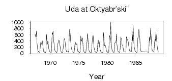
(Units: m3/s)
| ID | Year | Jan | Feb | Mar | Apr | May | Jun | Jul | Aug | Sep | Oct | Nov | Dec |
|---|
| 6504 | 1967 | | | | | 618.00 | 557.00 | 518.00 | 717.00 | 336.00 | 181.00 | 81.50 | 58.20 |
| 6504 | 1968 | 39.70 | 29.10 | 31.70 | 208.00 | 358.00 | 328.00 | 289.00 | 403.00 | 321.00 | 181.00 | 59.40 | 44.70 |
| 6504 | 1969 | 30.80 | 21.90 | 16.90 | 69.50 | 602.00 | 416.00 | 290.00 | 396.00 | 268.00 | 132.00 | 91.00 | 47.90 |
| 6504 | 1970 | 37.60 | 31.60 | 26.20 | 127.00 | 665.00 | 606.00 | 714.00 | 440.00 | 285.00 | 168.00 | 58.80 | 48.10 |
| 6504 | 1971 | 37.50 | 28.60 | 21.90 | 148.00 | 313.00 | 356.00 | 422.00 | 393.00 | 268.00 | 176.00 | 81.30 | 39.70 |
| 6504 | 1972 | 30.90 | 23.00 | 20.70 | 146.00 | 272.00 | 452.00 | 472.00 | 377.00 | 256.00 | 133.00 | 55.80 | 59.60 |
| 6504 | 1973 | 43.70 | 32.20 | 35.50 | 102.00 | 675.00 | 790.00 | 615.00 | 392.00 | 207.00 | 137.00 | 54.60 | 47.00 |
| 6504 | 1974 | 38.30 | 19.40 | 20.70 | 154.00 | 320.00 | 346.00 | 261.00 | 287.00 | 310.00 | 131.00 | 47.60 | 51.80 |
| 6504 | 1975 | 34.00 | 25.60 | 21.80 | 55.80 | 546.00 | 467.00 | 385.00 | 495.00 | 441.00 | 172.00 | 65.10 | 41.80 |
| 6504 | 1976 | 35.00 | 23.90 | 19.40 | 48.90 | 311.00 | 331.00 | 633.00 | 501.00 | 205.00 | 116.00 | 48.20 | 42.00 |
| 6504 | 1977 | 23.30 | 17.00 | 19.80 | 139.00 | 378.00 | 545.00 | 571.00 | 384.00 | 191.00 | 117.00 | 60.20 | 39.40 |
| 6504 | 1978 | 30.40 | 25.30 | 18.90 | 102.00 | 410.00 | 427.00 | 294.00 | 362.00 | 180.00 | 105.00 | 51.90 | 34.80 |
| 6504 | 1979 | 24.90 | 22.20 | 25.00 | 42.80 | 666.00 | 419.00 | 243.00 | 256.00 | 247.00 | 151.00 | 63.30 | 48.40 |
| 6504 | 1980 | 36.40 | 25.60 | 23.40 | 50.10 | 518.00 | 571.00 | 337.00 | 1000.00 | 329.00 | 193.00 | 90.60 | 67.90 |
| 6504 | 1981 | 46.20 | 30.70 | 27.60 | 307.00 | 336.00 | 359.00 | 358.00 | 622.00 | 321.00 | 163.00 | 67.40 | 50.50 |
| 6504 | 1982 | 37.70 | 27.50 | 26.90 | 203.00 | 521.00 | 468.00 | 444.00 | 260.00 | 254.00 | 181.00 | 73.30 | 36.20 |
| 6504 | 1983 | 41.30 | 38.20 | 37.40 | 54.00 | 530.00 | 478.00 | 435.00 | 406.00 | 357.00 | 217.00 | 110.00 | 61.20 |
| 6504 | 1984 | 49.20 | 37.30 | 36.20 | 56.10 | 623.00 | 393.00 | 895.00 | 505.00 | 228.00 | 147.00 | 72.30 | 53.30 |
| 6504 | 1985 | 36.60 | 30.30 | 25.10 | 190.00 | 489.00 | 541.00 | 775.00 | 594.00 | 494.00 | 201.00 | 88.60 | 52.70 |
| 6504 | 1987 | 36.90 | 31.90 | 27.60 | 89.90 | 524.00 | 399.00 | 457.00 | 806.00 | 529.00 | 268.00 | 90.80 | 63.80 |
| 6504 | 1988 | 52.80 | 39.70 | 33.20 | 302.00 | 457.00 | 396.00 | 687.00 | 520.00 | 327.00 | 164.00 | 82.10 | 50.90 |
 Return to R-Arctic Net Home Page