Angara at Ostrov Ujnost'
Yenisei
| PointID: | 6454 |
Code: | 8015 |
Latitude (decimal degrees): | 52.27 |
Longitude (decimal degrees): | 104.32 |
Drainage Area (km2): | 573000.00 |
Source: | SHI |
Hydrological Zone: | Yenisei |
Name: | Angara at Ostrov Ujnost' |
Field Definitions
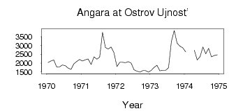
Site Time Series Plot:
Site Data File:
(Units: m3/s)
| ID | Year | Jan | Feb | Mar | Apr | May | Jun | Jul | Aug | Sep | Oct | Nov | Dec |
|---|
| 6454 | 1970 | 2030.00 | 2120.00 | 2180.00 | 1790.00 | 1780.00 | 1890.00 | 1850.00 | 1710.00 | 1640.00 | 1960.00 | 2090.00 | 2200.00 |
| 6454 | 1971 | 2120.00 | 2190.00 | 2230.00 | 1920.00 | 2360.00 | 2220.00 | 2340.00 | 3750.00 | 2890.00 | 2800.00 | 2920.00 | 2590.00 |
| 6454 | 1972 | 1810.00 | 2040.00 | 2040.00 | 2020.00 | 2080.00 | 2000.00 | 1620.00 | 1540.00 | 1480.00 | 1570.00 | 1570.00 | 1480.00 |
| 6454 | 1973 | 1590.00 | 1760.00 | 1870.00 | 1560.00 | 1590.00 | 1590.00 | 1740.00 | 3240.00 | 3860.00 | 3140.00 | 2960.00 | 2870.00 |
| 6454 | 1974 | 2640.00 | | | 2730.00 | 2180.00 | 2370.00 | 2920.00 | 2530.00 | 2840.00 | 2360.00 | 2430.00 | 2470.00 |
| Other Close Sites |
|---|
| PointID |
Latitude |
Longitude | Drainage Area | Source |
Name |
|---|
| 6453 | 52.23 | 104.30 | 573000.00 | SHI | Angara at Irkutskaya GES |
| 6463 | 52.28 | 104.28 | 15000.00 | SHI | Irkut at Irkutsk |
 Return to R-Arctic Net Home Page