Hila
Yenisei
| PointID: | 6452 |
Code: | 7191 |
Latitude (decimal degrees): | 51.73 |
Longitude (decimal degrees): | 111.95 |
Drainage Area (km2): | 1590.00 |
Source: | SHI |
Hydrological Zone: | Yenisei |
Name: | Hila |
Field Definitions
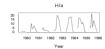
Site Time Series Plot:
Site Data File:
(Units: m3/s)
| ID | Year | Jan | Feb | Mar | Apr | May | Jun | Jul | Aug | Sep | Oct | Nov | Dec |
|---|
| 6452 | 1979 | | | | | | | 0.86 | 0.75 | 0.69 | 0.68 | 0.07 | |
| 6452 | 1980 | | | | 0.07 | 10.00 | 3.58 | 5.06 | 7.29 | 3.98 | 1.49 | 0.01 | |
| 6452 | 1981 | | | | 2.66 | 5.23 | 1.83 | 2.08 | 1.74 | 1.64 | 1.09 | 4.0e-03 | |
| 6452 | 1982 | | | | 1.13 | 1.67 | 3.79 | 19.90 | 18.60 | 14.70 | 6.43 | 0.52 | |
| 6452 | 1983 | | | | 0.17 | 4.07 | 9.00 | 17.20 | 17.30 | 18.20 | 9.96 | 0.76 | 0.05 |
| 6452 | 1984 | | | | 4.35 | 16.80 | 16.80 | 13.00 | 9.42 | 11.40 | 7.03 | 0.56 | 0.01 |
| 6452 | 1985 | | | | 6.18 | 4.99 | 22.10 | 5.34 | 13.60 | 9.41 | 5.99 | 0.41 | |
 Return to R-Arctic Net Home Page