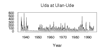
Uda at Ulan-Ude
Yenisei
| PointID: | 6439 |
Code: | 7130 |
Latitude (decimal degrees): | 51.83 |
Longitude (decimal degrees): | 107.63 |
Drainage Area (km2): | 34700.00 |
Source: | SHI |
Hydrological Zone: | Yenisei |
Name: | Uda at Ulan-Ude |
Field Definitions
Site Time Series Plot:
Site Data File:
(Units: m3/s)
| ID | Year | Jan | Feb | Mar | Apr | May | Jun | Jul | Aug | Sep | Oct | Nov | Dec |
|---|
| 6439 | 1936 | 8.24 | 4.87 | 4.90 | 20.50 | 312.00 | 472.00 | 123.00 | 132.00 | 343.00 | 171.00 | 44.50 | 25.40 |
| 6439 | 1937 | 23.60 | 17.30 | 13.20 | 60.90 | 206.00 | 87.40 | 121.00 | 90.20 | 114.00 | 75.70 | 33.80 | 26.30 |
| 6439 | 1938 | 15.50 | 9.73 | 8.23 | 70.50 | 86.70 | 163.00 | 211.00 | 183.00 | 587.00 | 233.00 | 36.30 | 37.10 |
| 6439 | 1939 | 30.80 | 24.80 | 18.70 | 176.00 | 131.00 | 114.00 | 90.30 | 91.40 | 75.80 | 53.70 | 25.30 | 22.80 |
| 6439 | 1940 | 13.80 | 9.78 | 8.68 | 56.20 | 137.00 | 140.00 | 452.00 | 178.00 | 112.00 | 75.80 | 32.20 | 29.80 |
| 6439 | 1941 | 16.40 | 12.60 | 11.60 | 39.50 | 163.00 | 171.00 | 93.30 | 147.00 | 203.00 | 99.00 | 35.80 | 25.70 |
| 6439 | 1950 | 16.90 | 13.20 | 12.00 | 42.00 | 132.00 | 84.40 | 56.30 | 86.80 | 132.00 | 98.60 | 31.80 | 26.90 |
| 6439 | 1951 | 17.10 | 13.50 | 12.40 | 43.40 | 220.00 | 92.70 | 83.30 | 81.50 | 88.70 | 93.00 | 32.70 | 20.00 |
| 6439 | 1952 | 16.50 | 13.30 | 11.50 | 42.60 | 235.00 | 122.00 | 125.00 | 94.20 | 119.00 | 90.20 | 32.40 | 19.20 |
| 6439 | 1953 | 10.60 | 6.87 | 8.97 | 68.70 | 196.00 | 103.00 | 79.40 | 59.00 | 46.00 | 44.30 | 16.20 | 10.00 |
| 6439 | 1954 | 7.76 | 7.69 | 6.94 | 32.20 | 92.30 | 74.20 | 101.00 | 92.40 | 61.50 | 45.70 | 21.60 | 10.70 |
| 6439 | 1955 | 5.53 | 4.53 | 6.95 | 31.50 | 122.00 | 68.40 | 63.00 | 48.00 | 58.40 | 54.10 | 22.70 | 11.50 |
| 6439 | 1956 | 5.64 | 3.68 | 6.97 | 21.70 | 107.00 | 96.00 | 94.30 | 153.00 | 121.00 | 75.40 | 16.50 | 11.50 |
| 6439 | 1957 | 6.43 | 5.08 | 5.52 | 39.50 | 139.00 | 124.00 | 69.50 | 91.60 | 105.00 | 78.00 | 24.00 | 20.70 |
| 6439 | 1958 | 12.70 | 7.82 | 7.02 | 26.20 | 140.00 | 70.10 | 42.20 | 39.90 | 30.20 | 32.60 | 15.60 | 8.67 |
| 6439 | 1959 | 2.83 | 2.53 | 5.92 | 35.70 | 88.00 | 121.00 | 118.00 | 221.00 | 192.00 | 111.00 | 35.80 | 19.70 |
| 6439 | 1960 | 14.10 | 10.20 | 11.60 | 47.80 | 103.00 | 86.30 | 69.10 | 81.30 | 131.00 | 90.70 | 28.10 | 22.80 |
| 6439 | 1961 | 15.90 | 13.80 | 14.00 | 62.40 | 91.00 | 88.60 | 106.00 | 147.00 | 162.00 | 92.70 | 29.50 | 23.70 |
| 6439 | 1962 | 16.40 | 14.00 | 14.30 | 73.60 | 147.00 | 143.00 | 311.00 | 160.00 | 107.00 | 80.70 | 35.30 | 19.70 |
| 6439 | 1963 | 13.70 | 8.71 | 14.70 | 40.40 | 126.00 | 100.00 | 115.00 | 88.80 | 90.70 | 79.30 | 26.80 | 19.00 |
| 6439 | 1964 | 13.70 | 9.70 | 8.05 | 24.80 | 170.00 | 164.00 | 109.00 | 77.10 | 89.50 | 59.70 | 33.20 | 20.70 |
| 6439 | 1965 | 18.00 | 8.65 | 11.40 | 51.80 | 119.00 | 94.70 | 62.90 | 76.60 | 85.10 | 67.40 | 21.70 | 13.50 |
| 6439 | 1966 | 10.60 | 8.86 | 8.39 | 25.30 | 147.00 | 90.20 | 99.20 | 133.00 | 83.20 | 64.40 | 20.90 | 13.00 |
| 6439 | 1967 | 6.44 | 5.58 | 8.52 | 62.30 | 101.00 | 55.90 | 137.00 | 128.00 | 121.00 | 93.40 | 38.60 | 18.00 |
| 6439 | 1968 | 11.80 | 7.18 | 12.60 | 78.40 | 262.00 | 132.00 | 85.00 | 69.80 | 73.90 | 59.30 | 24.40 | 15.00 |
| 6439 | 1969 | 9.23 | 5.51 | 5.23 | 26.70 | 88.50 | 64.20 | 38.90 | 148.00 | 202.00 | 96.10 | 34.30 | 32.50 |
| 6439 | 1970 | 13.90 | 10.30 | 11.80 | 49.20 | 125.00 | 102.00 | 89.50 | 83.10 | 117.00 | 93.80 | 28.30 | 17.10 |
| 6439 | 1971 | 11.60 | 8.82 | 6.51 | 75.70 | 116.00 | 92.40 | 92.50 | 279.00 | 119.00 | 82.80 | 39.50 | 25.30 |
| 6439 | 1972 | 11.60 | 9.34 | 8.63 | 46.70 | 87.90 | 60.80 | 89.40 | 71.80 | 54.00 | 44.70 | 28.70 | 10.40 |
| 6439 | 1973 | 5.90 | 4.74 | 6.19 | 29.30 | 152.00 | 162.00 | 137.00 | 193.00 | 148.00 | 92.50 | 44.70 | 43.20 |
| 6439 | 1974 | 28.20 | 20.10 | 14.00 | 43.60 | 90.70 | 123.00 | 63.90 | 45.70 | 42.60 | 34.90 | 17.40 | 10.60 |
| 6439 | 1975 | 5.85 | 5.35 | 10.00 | 38.20 | 130.00 | 95.30 | 68.20 | 66.90 | 74.60 | 63.70 | 34.10 | 12.50 |
| 6439 | 1976 | 8.40 | 7.08 | 7.92 | 27.10 | 75.50 | 54.60 | 61.00 | 63.60 | 57.40 | 42.70 | 16.20 | 10.90 |
| 6439 | 1977 | 4.96 | 3.28 | 3.29 | 30.80 | 91.50 | 80.00 | 45.10 | 39.60 | 32.90 | 26.40 | 16.70 | 12.50 |
| 6439 | 1978 | 9.48 | 7.71 | 4.95 | 26.90 | 49.20 | 42.40 | 79.60 | 53.50 | 96.80 | 56.30 | 19.90 | 11.70 |
| 6439 | 1979 | 7.13 | 5.09 | 5.74 | 19.00 | 135.00 | 58.20 | 33.60 | 31.40 | 31.40 | 31.00 | 15.40 | 9.15 |
| 6439 | 1980 | 6.20 | 3.68 | 2.99 | 11.80 | 87.10 | 76.70 | 68.80 | 75.60 | 52.30 | 38.90 | 22.00 | 15.00 |
| 6439 | 1981 | 7.38 | 4.44 | 7.08 | 42.40 | 61.10 | 42.50 | 31.60 | 47.40 | 48.30 | 37.30 | 18.20 | 10.20 |
| 6439 | 1982 | 6.45 | 5.11 | 4.24 | 27.30 | 50.10 | 70.80 | 113.00 | 147.00 | 126.00 | 79.90 | 38.30 | 22.10 |
| 6439 | 1983 | 13.50 | 8.47 | 10.60 | 21.70 | 98.00 | 121.00 | 122.00 | 185.00 | 146.00 | 106.00 | 38.20 | 32.40 |
| 6439 | 1984 | 19.60 | 12.30 | 12.30 | 28.60 | 183.00 | 229.00 | 167.00 | 150.00 | 192.00 | 133.00 | 55.10 | 40.30 |
| 6439 | 1985 | 16.20 | 10.30 | 9.59 | 55.70 | 116.00 | 483.00 | 151.00 | 223.00 | 216.00 | 126.00 | 53.00 | 50.90 |
| 6439 | 1986 | 25.30 | 12.80 | 13.50 | 39.80 | 134.00 | 129.00 | 122.00 | 81.90 | 136.00 | 79.50 | 55.80 | 38.20 |
| 6439 | 1987 | 12.10 | 7.95 | 10.30 | 27.40 | 77.10 | 70.50 | 74.50 | 57.00 | 53.00 | 44.20 | 18.10 | 11.70 |
| 6439 | 1988 | 9.19 | 8.02 | 9.38 | 25.10 | 89.10 | 74.30 | 249.00 | 232.00 | 305.00 | 135.00 | 46.60 | 34.60 |
| 6439 | 1989 | 23.50 | 15.40 | 19.40 | 60.80 | 76.90 | 63.60 | 55.10 | 52.80 | 55.00 | 48.30 | 20.80 | 11.60 |
| 6439 | 1991 | 17.70 | 12.10 | 16.90 | 60.20 | 152.00 | 106.00 | 296.00 | 206.00 | 149.00 | 136.00 | 58.60 | 26.10 |
| 6439 | 1992 | 18.10 | 15.10 | 17.20 | 68.90 | 172.00 | 106.00 | 94.90 | 84.90 | 121.00 | 88.80 | 40.60 | 26.30 |
| 6439 | 1993 | 19.30 | 15.20 | 18.60 | 60.60 | 135.00 | 65.00 | 50.30 | 75.00 | 81.70 | 88.50 | 37.30 | 23.30 |
| 6439 | 1994 | 16.80 | 14.90 | 22.30 | 56.60 | 104.00 | 86.80 | 116.00 | 124.00 | 173.00 | 122.00 | 47.10 | 34.40 |
| Other Close Sites |
|---|
| PointID |
Latitude |
Longitude | Drainage Area | Source |
Name |
|---|
| 6412 | 52.03 | 107.48 | 440000.00 | SHI | Selenga at Mostovoi' |
 Return to R-Arctic Net Home Page