Vost. Handyga at Zapa
Lena
| PointID: | 6336 |
Code: | 3629 |
Latitude (decimal degrees): | 63.13 |
Longitude (decimal degrees): | 138.28 |
Drainage Area (km2): | 2510.00 |
Source: | SHI |
Hydrological Zone: | Lena |
Name: | Vost. Handyga at Zapa |
Field Definitions
Site Time Series Plot:
Site Data File:
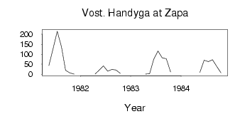
(Units: m3/s)
| ID | Year | Jan | Feb | Mar | Apr | May | Jun | Jul | Aug | Sep | Oct | Nov | Dec |
|---|
| 6336 | 1981 | | | | | 43.10 | 129.00 | 215.00 | 137.00 | 19.60 | 6.82 | 0.44 | |
| 6336 | 1982 | | | | 0.28 | 21.30 | 42.10 | 14.70 | 24.10 | 21.20 | 3.67 | | |
| 6336 | 1983 | | | | 0.28 | 2.26 | 73.90 | 116.00 | 81.90 | 77.30 | 11.50 | | |
| 6336 | 1984 | | | | | 9.03 | 70.20 | 62.70 | 72.60 | 39.50 | 6.77 | | |
 Return to R-Arctic Net Home Page