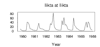
Ilikta at Ilikta
Lena
| PointID: | 6332 |
Code: | 3603 |
Latitude (decimal degrees): | 53.82 |
Longitude (decimal degrees): | 106.47 |
Drainage Area (km2): | 2850.00 |
Source: | SHI |
Hydrological Zone: | Lena |
Name: | Ilikta at Ilikta |
Field Definitions
Site Time Series Plot:
Site Data File:
(Units: m3/s)
| ID | Year | Jan | Feb | Mar | Apr | May | Jun | Jul | Aug | Sep | Oct | Nov | Dec |
|---|
| 6332 | 1979 | | | | | | | | | | 9.46 | 3.87 | 2.85 |
| 6332 | 1980 | 2.36 | 2.31 | 2.30 | 3.25 | 41.30 | 39.20 | 30.50 | 10.80 | 9.69 | 7.84 | 4.38 | 3.89 |
| 6332 | 1981 | 3.62 | 3.13 | 3.06 | 17.70 | 36.20 | 13.30 | 11.00 | 10.20 | 9.51 | 6.83 | 3.67 | 3.39 |
| 6332 | 1982 | 2.70 | 2.29 | 2.52 | 6.31 | 34.60 | 28.60 | 43.50 | 83.80 | 20.80 | 12.50 | 7.18 | 6.12 |
| 6332 | 1983 | 5.11 | 4.41 | 4.09 | 4.60 | 48.30 | 28.40 | 62.30 | 27.50 | 29.60 | 22.40 | 8.66 | 6.99 |
| 6332 | 1984 | 5.67 | 4.49 | 4.29 | 5.13 | 60.60 | 25.10 | 20.70 | 12.70 | 10.10 | 7.37 | 3.49 | 3.22 |
| 6332 | 1985 | 2.53 | 2.40 | 2.33 | 4.60 | 24.90 | 41.40 | 16.60 | 42.30 | 35.80 | 15.30 | 6.91 | 5.67 |
 Return to R-Arctic Net Home Page