Tungir at Gulya
Lena
| PointID: | 6328 |
Code: | 3578 |
Latitude (decimal degrees): | 54.67 |
Longitude (decimal degrees): | 120.98 |
Drainage Area (km2): | 8380.00 |
Source: | SHI |
Hydrological Zone: | Lena |
Name: | Tungir at Gulya |
Field Definitions
Site Time Series Plot:
Site Data File:
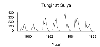
(Units: m3/s)
| ID | Year | Jan | Feb | Mar | Apr | May | Jun | Jul | Aug | Sep | Oct | Nov | Dec |
|---|
| 6328 | 1979 | | | | 2.40 | 66.60 | 26.40 | 18.70 | 145.00 | 129.00 | 38.50 | 3.78 | 0.12 |
| 6328 | 1980 | | | | 0.30 | 74.60 | 57.60 | 155.00 | 21.80 | 35.00 | 22.50 | 1.31 | 0.06 |
| 6328 | 1981 | | | | 7.09 | 45.10 | 221.00 | 153.00 | 280.00 | 164.00 | 56.10 | 4.02 | 0.03 |
| 6328 | 1982 | | | | 12.30 | 172.00 | 89.80 | 215.00 | 272.00 | 110.00 | 26.50 | 2.04 | 0.15 |
| 6328 | 1983 | | | | | 328.00 | 395.00 | 164.00 | 60.40 | 157.00 | 47.00 | 4.02 | 0.49 |
| 6328 | 1984 | | | | 31.50 | 277.00 | 141.00 | 273.00 | 271.00 | 143.00 | 35.60 | 3.87 | 0.10 |
| 6328 | 1985 | | | | 8.19 | 206.00 | 83.50 | 67.90 | 79.90 | 150.00 | 54.70 | 8.17 | 0.09 |
 Return to R-Arctic Net Home Page