Anga at Chaptyhoi
Lena
| PointID: | 6326 |
Code: | 3576 |
Latitude (decimal degrees): | 53.98 |
Longitude (decimal degrees): | 106.08 |
Drainage Area (km2): | 2350.00 |
Source: | SHI |
Hydrological Zone: | Lena |
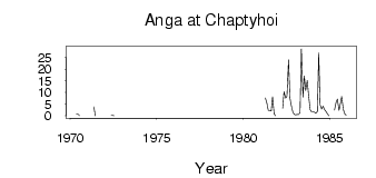
Name: | Anga at Chaptyhoi |
Field Definitions
Site Time Series Plot:
Site Data File:
(Units: m3/s)
| ID | Year | Jan | Feb | Mar | Apr | May | Jun | Jul | Aug | Sep | Oct | Nov | Dec |
|---|
| 6326 | 1970 | | | | | 0.81 | 0.75 | 0.04 | | | | | |
| 6326 | 1971 | | | | | 3.87 | 0.02 | | | | | | |
| 6326 | 1972 | | | | | 0.15 | 0.11 | 5.0e-03 | | | | | |
| 6326 | 1981 | | | | 7.66 | 5.26 | 2.30 | 2.19 | 2.06 | 8.18 | 0.78 | 0.09 | |
| 6326 | 1982 | | | | 3.22 | 10.40 | 7.55 | 8.37 | 24.00 | 7.70 | 4.53 | 1.64 | 0.58 |
| 6326 | 1983 | 0.42 | 0.62 | 0.52 | 1.27 | 28.70 | 8.06 | 17.10 | 10.80 | 15.10 | 8.75 | 2.61 | 1.73 |
| 6326 | 1984 | 1.79 | 1.48 | 1.02 | 1.90 | 27.00 | 4.71 | 2.95 | 4.17 | 2.59 | 1.92 | 0.97 | 0.04 |
| 6326 | 1985 | | | | 2.43 | 5.71 | 7.14 | 2.34 | 5.05 | 8.34 | 2.79 | 0.90 | 0.29 |
 Return to R-Arctic Net Home Page