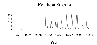
Konda at Kuanda
Lena
| PointID: | 6324 |
Code: | 3569 |
Latitude (decimal degrees): | 56.35 |
Longitude (decimal degrees): | 116.23 |
Drainage Area (km2): | 3160.00 |
Source: | SHI |
Hydrological Zone: | Lena |
Name: | Konda at Kuanda |
Field Definitions
Site Time Series Plot:
Site Data File:
(Units: m3/s)
| ID | Year | Jan | Feb | Mar | Apr | May | Jun | Jul | Aug | Sep | Oct | Nov | Dec |
|---|
| 6324 | 1972 | | | | | 1.03 | 1.71 | 1.14 | 1.03 | 0.41 | 0.05 | | |
| 6324 | 1977 | 3.26 | 2.25 | 1.75 | 3.19 | 56.10 | 210.00 | 84.90 | 89.70 | 91.00 | 16.50 | 7.47 | 4.68 |
| 6324 | 1978 | 3.46 | 2.37 | 2.02 | 6.22 | 35.70 | 192.00 | 126.00 | 61.00 | 31.80 | 16.70 | 7.51 | 4.79 |
| 6324 | 1979 | 3.88 | 2.53 | 2.45 | 3.71 | 104.00 | 63.50 | 38.90 | 148.00 | 107.00 | 17.80 | 7.08 | 5.13 |
| 6324 | 1980 | 3.39 | 3.31 | 3.18 | 3.96 | 17.30 | 157.00 | 101.00 | 39.80 | 21.30 | 10.50 | 5.56 | 4.41 |
| 6324 | 1981 | 2.68 | 1.88 | 1.60 | 3.35 | 29.20 | 124.00 | 225.00 | 107.00 | 54.60 | 18.00 | 9.33 | 5.86 |
| 6324 | 1982 | 4.81 | 2.38 | 3.13 | 5.58 | 45.40 | 230.00 | 149.00 | 143.00 | 54.40 | 21.70 | 6.88 | 5.19 |
| 6324 | 1983 | 4.34 | 4.14 | 4.57 | 3.99 | 62.20 | 202.00 | 182.00 | 240.00 | 90.10 | 18.50 | 8.64 | 5.66 |
| 6324 | 1984 | 4.38 | 3.91 | 4.45 | 5.77 | 121.00 | 116.00 | 74.50 | 59.60 | 36.40 | 15.10 | 8.82 | 3.86 |
| 6324 | 1985 | 2.99 | 1.46 | 1.73 | 5.66 | 32.20 | 118.00 | 36.00 | 16.70 | 24.90 | 10.80 | 5.93 | 2.91 |
 Return to R-Arctic Net Home Page