Sutam at Sutam
Lena
| PointID: | 6322 |
Code: | 3566 |
Latitude (decimal degrees): | 55.97 |
Longitude (decimal degrees): | 127.58 |
Drainage Area (km2): | 4180.00 |
Source: | SHI |
Hydrological Zone: | Lena |
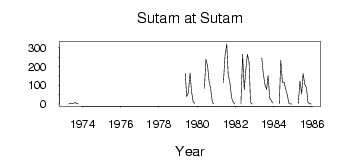
Name: | Sutam at Sutam |
Field Definitions
Site Time Series Plot:
Site Data File:
(Units: m3/s)
| ID | Year | Jan | Feb | Mar | Apr | May | Jun | Jul | Aug | Sep | Oct | Nov | Dec |
|---|
| 6322 | 1973 | | | | 0.05 | 5.81 | 2.42 | 4.56 | 8.26 | 2.90 | 0.62 | | |
| 6322 | 1979 | | | | | 164.00 | 39.50 | 61.80 | 165.00 | 69.00 | 12.20 | 2.72 | |
| 6322 | 1980 | | | | | 84.30 | 238.00 | 205.00 | 125.00 | 78.30 | 9.28 | 0.14 | |
| 6322 | 1981 | | | | | 114.00 | 263.00 | 321.00 | 157.00 | 115.00 | 34.90 | 12.20 | 0.02 |
| 6322 | 1982 | | | | 0.80 | 265.00 | 75.70 | 178.00 | 265.00 | 225.00 | 9.90 | 0.23 | |
| 6322 | 1983 | | | | | 246.00 | 164.00 | 104.00 | 78.40 | 151.00 | 31.90 | 16.30 | 5.59 |
| 6322 | 1984 | | | | 3.59 | 233.00 | 116.00 | 117.00 | 82.60 | 48.50 | 6.04 | 0.81 | 0.03 |
| 6322 | 1985 | | | | 2.76 | 124.00 | 54.00 | 163.00 | 106.00 | 87.30 | 11.40 | 1.78 | 0.02 |
 Return to R-Arctic Net Home Page