Kobuma at Kobuma
Lena
| PointID: | 6306 |
Code: | 3500 |
Latitude (decimal degrees): | 63.43 |
Longitude (decimal degrees): | 140.60 |
Drainage Area (km2): | 1830.00 |
Source: | SHI |
Hydrological Zone: | Lena |
Name: | Kobuma at Kobuma |
Field Definitions
Site Time Series Plot:
Site Data File:
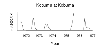
(Units: m3/s)
| ID | Year | Jan | Feb | Mar | Apr | May | Jun | Jul | Aug | Sep | Oct | Nov | Dec |
|---|
| 6306 | 1971 | | | | | | | 23.90 | 25.80 | 18.60 | 2.10 | 0.02 | |
| 6306 | 1972 | | | | | 0.23 | 11.50 | 40.40 | 24.40 | 5.01 | 1.17 | 0.01 | |
| 6306 | 1973 | | | | | 1.29 | 19.20 | 11.30 | 17.10 | 7.83 | 4.67 | 0.77 | |
| 6306 | 1974 | | | | | 1.79 | | | | | | | |
| 6306 | 1975 | | | | | 1.43 | 11.90 | 27.00 | 54.40 | | | | |
| 6306 | 1976 | | | | | 1.22 | 38.10 | 11.50 | 6.33 | 7.34 | 4.89 | 2.45 | |
 Return to R-Arctic Net Home Page