| PointID: | 6287 | Code: | 3394 | Latitude (decimal degrees): | 67.12 | Longitude (decimal degrees): | 126.20 | Drainage Area (km2): | 7090.00 | Source: | SHI | Hydrological Zone: | Lena | Name: | Sobolooh-Maian at Sobopol |
|---|
| Download | |
|---|---|
| Site Descriptor Information | Site Time Series Data |
| Link to all available data | |
| ID | Year | Jan | Feb | Mar | Apr | May | Jun | Jul | Aug | Sep | Oct | Nov | Dec |
|---|---|---|---|---|---|---|---|---|---|---|---|---|---|
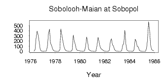
| 6287 | 1976 | 5.29 | 33.60 | 250.00 | 393.00 | 316.00 | 179.00 | 40.10 | 8.69 | 2.70 | |||
| 6287 | 1977 | 1.52 | 2.54 | 3.59 | 7.58 | 97.90 | 352.00 | 430.00 | 159.00 | 117.00 | 46.40 | 17.30 | 4.97 |
| 6287 | 1978 | 2.73 | 0.98 | 0.69 | 2.66 | 32.40 | 435.00 | 313.00 | 193.00 | 97.30 | 35.40 | 15.20 | 7.98 |
| 6287 | 1979 | 4.57 | 2.23 | 1.87 | 3.69 | 29.90 | 316.00 | 205.00 | 134.00 | 39.20 | 19.20 | 17.10 | 13.50 |
| 6287 | 1980 | 8.33 | 5.01 | 2.02 | 2.91 | 11.10 | 94.00 | 280.00 | 174.00 | 40.50 | 21.70 | 10.40 | 4.55 |
| 6287 | 1981 | 2.79 | 1.64 | 1.00 | 2.73 | 109.00 | 272.00 | 196.00 | 89.70 | 48.50 | 36.90 | 22.60 | 6.84 |
| 6287 | 1982 | 3.50 | 1.60 | 1.10 | 4.58 | 21.60 | 196.00 | 245.00 | 133.00 | 102.00 | 36.70 | 12.90 | 5.18 |
| 6287 | 1983 | 2.93 | 1.05 | 0.70 | 1.89 | 18.40 | 120.00 | 156.00 | 409.00 | 140.00 | 28.10 | 10.10 | 4.72 |
| 6287 | 1984 | 3.25 | 2.90 | 2.26 | 4.50 | 38.30 | 235.00 | 196.00 | 95.70 | 88.60 | 24.90 | 8.24 | 2.56 |
| 6287 | 1985 | 1.88 | 1.27 | 0.50 | 1.68 | 58.10 | 219.00 | 576.00 | 405.00 | 123.00 | 36.50 | 20.00 | 9.58 |
 Return to R-Arctic Net Home Page