Morkoka at Habardino
Lena
| PointID: | 6282 |
Code: | 3383 |
Latitude (decimal degrees): | 64.60 |
Longitude (decimal degrees): | 112.52 |
Drainage Area (km2): | 18600.00 |
Source: | SHI |
Hydrological Zone: | Lena |
Name: | Morkoka at Habardino |
Field Definitions
Site Time Series Plot:
Site Data File:
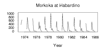
(Units: m3/s)
| ID | Year | Jan | Feb | Mar | Apr | May | Jun | Jul | Aug | Sep | Oct | Nov | Dec |
|---|
| 6282 | 1973 | | | | | 370.00 | 540.00 | 635.00 | | | | | |
| 6282 | 1974 | | | | | 122.00 | 783.00 | 526.00 | 193.00 | 160.00 | 33.70 | 12.00 | 0.28 |
| 6282 | 1975 | | | | | 713.00 | 343.00 | 29.00 | 8.19 | 22.40 | 7.99 | 1.35 | 0.57 |
| 6282 | 1976 | 0.11 | | | | 111.00 | 530.00 | 151.00 | 306.00 | 86.30 | 27.90 | 1.55 | 0.15 |
| 6282 | 1977 | | | | | 386.00 | 815.00 | 75.20 | 151.00 | 120.00 | 19.70 | 2.71 | 0.51 |
| 6282 | 1978 | | | | | 190.00 | 1010.00 | 121.00 | 64.10 | 148.00 | 30.60 | 3.91 | 0.36 |
| 6282 | 1979 | | | | | 216.00 | 552.00 | 32.50 | 32.10 | 51.70 | 22.50 | 1.53 | |
| 6282 | 1980 | | | | | 41.60 | 995.00 | 241.00 | 177.00 | 64.20 | 12.60 | 1.19 | 0.63 |
| 6282 | 1981 | 0.01 | | | 0.02 | 542.00 | 335.00 | 118.00 | 10.80 | 47.40 | 11.60 | 1.38 | 0.76 |
| 6282 | 1982 | 0.12 | | | | 284.00 | 785.00 | 80.80 | 23.70 | 106.00 | 20.40 | 2.22 | 0.65 |
| 6282 | 1983 | 0.07 | | | | 257.00 | 638.00 | 98.60 | 14.90 | 166.00 | 14.80 | 2.56 | 1.23 |
| 6282 | 1984 | 0.07 | | | | 424.00 | 420.00 | 18.00 | 13.00 | 29.80 | 5.30 | 0.60 | 0.26 |
| 6282 | 1985 | 0.04 | | | | 73.90 | 524.00 | 223.00 | 34.60 | 49.40 | 19.00 | 1.25 | 0.21 |
 Return to R-Arctic Net Home Page