Tanda at Byariya
Lena
| PointID: | 6260 |
Code: | 3306 |
Latitude (decimal degrees): | 62.98 |
Longitude (decimal degrees): | 131.90 |
Drainage Area (km2): | 2000.00 |
Source: | SHI |
Hydrological Zone: | Lena |
Name: | Tanda at Byariya |
Field Definitions
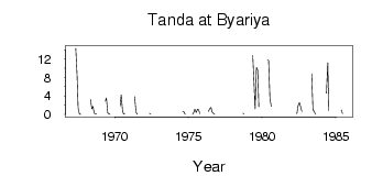
Site Time Series Plot:
Site Data File:
(Units: m3/s)
| ID | Year | Jan | Feb | Mar | Apr | May | Jun | Jul | Aug | Sep | Oct | Nov | Dec |
|---|
| 6260 | 1967 | | | | | 14.30 | 8.41 | 1.40 | 0.07 | 8.0e-03 | | | |
| 6260 | 1968 | | | | | 3.24 | 1.22 | 1.71 | 0.27 | 0.18 | 0.05 | | |
| 6260 | 1969 | | | | | 2.85 | 3.58 | 0.34 | 0.14 | 2.0e-03 | | | |
| 6260 | 1970 | | | | | 1.85 | 4.25 | 0.86 | 0.07 | 0.05 | | | |
| 6260 | 1971 | | | | | 3.83 | 0.55 | 0.02 | | | | | |
| 6260 | 1972 | | | | | 0.24 | 0.16 | | | | | | |
| 6260 | 1973 | | | | | | 0.21 | | 0.05 | | | | |
| 6260 | 1974 | | | | | | | | 0.62 | 0.61 | 0.01 | | |
| 6260 | 1975 | | | | 7.0e-03 | 0.45 | 1.17 | 0.44 | 1.16 | 1.05 | 0.19 | | |
| 6260 | 1976 | | | | | 0.71 | 1.20 | 1.55 | 0.53 | 0.22 | 0.03 | | |
| 6260 | 1978 | | | | | | | | | 0.23 | 0.11 | | |
| 6260 | 1979 | | | | | 12.80 | 6.59 | 1.24 | 10.20 | 9.53 | 1.69 | | |
| 6260 | 1980 | | | | | 11.70 | 11.70 | 3.58 | 1.74 | | | | |
| 6260 | 1982 | | | | | 0.11 | 1.94 | 2.61 | 1.76 | 0.67 | | | |
| 6260 | 1983 | | | | | 8.79 | 0.95 | 0.69 | 0.02 | | | | |
| 6260 | 1984 | | | | | 4.60 | 11.20 | 0.88 | | | | | |
| 6260 | 1985 | | | | | 1.00 | 0.19 | | | | | | |
 Return to R-Arctic Net Home Page