Tompo at Topolinyi
Lena
| PointID: | 6258 |
Code: | 3295 |
Latitude (decimal degrees): | 64.08 |
Longitude (decimal degrees): | 135.97 |
Drainage Area (km2): | 25500.00 |
Source: | SHI |
Hydrological Zone: | Lena |
Name: | Tompo at Topolinyi |
Field Definitions
Site Time Series Plot:
Site Data File:
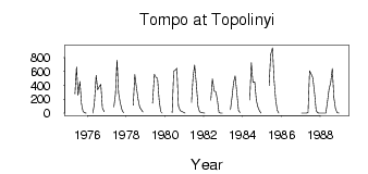
(Units: m3/s)
| ID | Year | Jan | Feb | Mar | Apr | May | Jun | Jul | Aug | Sep | Oct | Nov | Dec |
|---|
| 6258 | 1975 | | | | | 279.00 | 669.00 | 257.00 | 457.00 | 133.00 | 25.50 | 5.35 | 4.0e-03 |
| 6258 | 1976 | | | | 6.0e-03 | 121.00 | 548.00 | 337.00 | 382.00 | 416.00 | 77.20 | 18.20 | |
| 6258 | 1977 | | | | | 92.40 | 271.00 | 765.00 | 289.00 | 155.00 | 47.90 | 4.44 | |
| 6258 | 1978 | | | | | 113.00 | 560.00 | 381.00 | 193.00 | 85.60 | 49.20 | 15.90 | |
| 6258 | 1979 | | | | | 144.00 | 562.00 | 518.00 | 501.00 | 197.00 | 23.50 | 0.14 | |
| 6258 | 1980 | | | | | 10.60 | 607.00 | 618.00 | 650.00 | 102.00 | 36.20 | 24.00 | 11.90 |
| 6258 | 1981 | 1.34 | | | | 154.00 | 523.00 | 693.00 | 396.00 | 96.90 | 19.30 | 9.71 | 3.72 |
| 6258 | 1982 | 0.03 | | | | 187.00 | 494.00 | 319.00 | 309.00 | 192.00 | 13.50 | 1.57 | 0.32 |
| 6258 | 1983 | | | | | 50.80 | 230.00 | 438.00 | 539.00 | 318.00 | 38.70 | 7.78 | |
| 6258 | 1984 | | | | | 190.00 | 727.00 | 447.00 | 452.00 | 188.00 | 91.20 | 35.70 | 0.90 |
| 6258 | 1985 | | | | | 395.00 | 843.00 | 944.00 | 483.00 | 202.00 | 42.40 | 0.08 | |
| 6258 | 1987 | 0.00 | 0.00 | 0.00 | 0.00 | 9.10 | 611.00 | 568.00 | 513.00 | 289.00 | 33.30 | 5.59 | 0.62 |
| 6258 | 1988 | 0.00 | 0.00 | 0.00 | 0.00 | 154.00 | 335.00 | 448.00 | 644.00 | 222.00 | 69.00 | 10.10 | 0.00 |
 Return to R-Arctic Net Home Page