Vost. Handyga at Zapa
Lena
| PointID: | 6254 |
Code: | 3288 |
Latitude (decimal degrees): | 63.13 |
Longitude (decimal degrees): | 138.28 |
Drainage Area (km2): | 2510.00 |
Source: | SHI |
Hydrological Zone: | Lena |
Name: | Vost. Handyga at Zapa |
Field Definitions
Site Time Series Plot:
Site Data File:
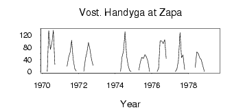
(Units: m3/s)
| ID | Year | Jan | Feb | Mar | Apr | May | Jun | Jul | Aug | Sep | Oct | Nov | Dec |
|---|
| 6254 | 1970 | | | | 0.55 | 135.00 | 73.00 | 93.00 | 136.00 | 23.30 | | | |
| 6254 | 1971 | | | | | 17.10 | 47.90 | 63.60 | 103.00 | 41.80 | 9.36 | 1.83 | |
| 6254 | 1972 | | | | 1.02 | 43.10 | 63.80 | 95.50 | 73.50 | 39.20 | 20.00 | | |
| 6254 | 1974 | | | | 9.0e-03 | 47.90 | 67.60 | 131.00 | 50.90 | 20.30 | 3.49 | 0.04 | |
| 6254 | 1975 | | | | 4.63 | 31.00 | 47.10 | 42.90 | 55.60 | 48.10 | 33.30 | 0.19 | |
| 6254 | 1976 | | | | 0.04 | 10.90 | 101.00 | 100.00 | 92.10 | 105.00 | 42.80 | | |
| 6254 | 1977 | | | | 0.02 | 8.08 | 35.50 | 128.00 | 45.80 | 54.50 | 6.46 | | |
| 6254 | 1978 | | | | | 14.00 | 64.50 | 58.60 | 44.60 | 38.50 | 17.80 | 0.16 | |
| 6254 | 1979 | | | | | 2.61 | | | | | | | |
 Return to R-Arctic Net Home Page