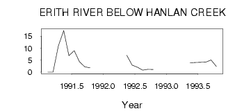
| PointID: | 625 | Code: | 07AF016 | Latitude (decimal degrees): | 53.23 | Longitude (decimal degrees): | -116.56 | Drainage Area (km2): | Source: | Hydat | Hydrological Zone: | Mackenzie | Name: | ERITH RIVER BELOW HANLAN CREEK |
|---|
| Download | |
|---|---|
| Site Descriptor Information | Site Time Series Data |
| Link to all available data | |
| ID | Year | Jan | Feb | Mar | Apr | May | Jun | Jul | Aug | Sep | Oct | Nov | Dec |
|---|---|---|---|---|---|---|---|---|---|---|---|---|---|
| 625 | 1991 | 0.00 | 0.00 | 11.00 | 17.40 | 6.91 | 8.98 | 4.43 | 2.27 | 1.83 | |||
| 625 | 1992 | 7.02 | 2.95 | 2.08 | 0.84 | 1.21 | 1.15 | ||||||
| 625 | 1993 | 3.90 | 4.08 | 4.12 | 4.22 | 5.10 | 2.36 |
 Return to R-Arctic Net Home Page