Allah-Un at Selhoz
Lena
| PointID: | 6249 |
Code: | 3275 |
Latitude (decimal degrees): | 60.28 |
Longitude (decimal degrees): | 137.50 |
Drainage Area (km2): | 15000.00 |
Source: | SHI |
Hydrological Zone: | Lena |
Name: | Allah-Un at Selhoz |
Field Definitions
Site Time Series Plot:
Site Data File:
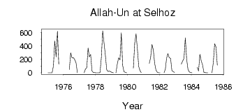
(Units: m3/s)
| ID | Year | Jan | Feb | Mar | Apr | May | Jun | Jul | Aug | Sep | Oct | Nov | Dec |
|---|
| 6249 | 1975 | 0.54 | 0.16 | 9.0e-03 | 0.56 | 104.00 | 475.00 | 238.00 | 620.00 | 127.00 | | | |
| 6249 | 1976 | | | | | 51.70 | 297.00 | 221.00 | 228.00 | 196.00 | 149.00 | 1.40 | |
| 6249 | 1977 | | | | 0.03 | 55.00 | 77.90 | 369.00 | 238.00 | 273.00 | 28.60 | 6.23 | 2.83 |
| 6249 | 1978 | 1.54 | 1.48 | 1.08 | 2.94 | 230.00 | 625.00 | 445.00 | 261.00 | 45.00 | 21.30 | 26.50 | 15.90 |
| 6249 | 1979 | 6.44 | 0.56 | | 0.08 | 131.00 | 222.00 | 193.00 | 595.00 | 113.00 | 15.00 | 7.28 | 0.93 |
| 6249 | 1980 | | | | | 69.00 | 438.00 | 579.00 | 355.00 | 93.60 | 31.40 | 2.09 | |
| 6249 | 1981 | | | | | 141.00 | 227.00 | 423.00 | 342.00 | 143.00 | 38.40 | 8.11 | 1.78 |
| 6249 | 1982 | 0.61 | | | 0.01 | 55.40 | 215.00 | 286.00 | 225.00 | 216.00 | 32.10 | 18.00 | 4.92 |
| 6249 | 1983 | | | | | 131.00 | 176.00 | 212.00 | 520.00 | 204.00 | 49.90 | 13.00 | 5.18 |
| 6249 | 1984 | 1.86 | | | | 81.00 | 28.00 | 274.00 | 179.00 | 118.00 | 6.97 | 2.74 | 1.30 |
| 6249 | 1985 | 0.54 | | | 0.18 | 150.00 | 432.00 | 385.00 | 114.00 | | | | |
 Return to R-Arctic Net Home Page