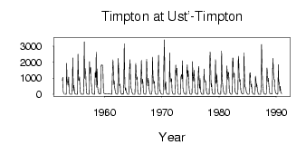
Timpton at Ust'-Timpton
Lena
| PointID: | 6242 |
Code: | 3248 |
Latitude (decimal degrees): | 58.65 |
Longitude (decimal degrees): | 127.05 |
Drainage Area (km2): | 43700.00 |
Source: | SHI |
Hydrological Zone: | Lena |
Name: | Timpton at Ust'-Timpton |
Field Definitions
Site Time Series Plot:
Site Data File:
(Units: m3/s)
| ID | Year | Jan | Feb | Mar | Apr | May | Jun | Jul | Aug | Sep | Oct | Nov | Dec |
|---|
| 6242 | 1952 | | | | | | | | 859.00 | 1060.00 | 175.00 | 27.30 | |
| 6242 | 1953 | 11.50 | 7.94 | 5.52 | 8.10 | 1930.00 | 788.00 | 788.00 | 569.00 | 1080.00 | 269.00 | 40.50 | 18.80 |
| 6242 | 1954 | 9.19 | 8.10 | 4.78 | 3.73 | 485.00 | 2270.00 | 222.00 | 564.00 | 316.00 | 93.10 | 21.60 | 13.30 |
| 6242 | 1955 | 5.33 | 3.27 | 2.11 | 2.12 | 2490.00 | 892.00 | 848.00 | 1090.00 | 449.00 | 132.00 | 30.30 | 11.20 |
| 6242 | 1956 | 6.95 | 4.60 | 2.00 | 2.23 | 507.00 | 3260.00 | 994.00 | 1620.00 | 1180.00 | 401.00 | 59.90 | 34.00 |
| 6242 | 1957 | 16.70 | 8.80 | 4.48 | 7.79 | 2030.00 | 1290.00 | 1680.00 | 685.00 | 647.00 | 206.00 | 50.50 | 26.90 |
| 6242 | 1958 | 7.31 | 4.59 | 3.09 | 10.60 | 1350.00 | 1030.00 | 2630.00 | 442.00 | 1580.00 | 492.00 | 162.00 | 84.40 |
| 6242 | 1959 | 25.20 | 22.60 | 20.50 | 26.60 | 1720.00 | 1830.00 | 1830.00 | 1830.00 | 1470.00 | 332.00 | 96.50 | 49.30 |
| 6242 | 1961 | 12.00 | 9.30 | 6.85 | 7.95 | 1110.00 | 2140.00 | 1560.00 | 618.00 | 829.00 | 426.00 | 157.00 | 55.70 |
| 6242 | 1962 | 17.10 | 12.70 | 7.15 | 9.70 | 2240.00 | 1760.00 | 643.00 | 526.00 | 643.00 | 159.00 | 75.60 | 17.00 |
| 6242 | 1963 | 6.40 | 41.40 | 2.85 | 4.25 | 689.00 | 3140.00 | 511.00 | 245.00 | 396.00 | 150.00 | 117.00 | 12.40 |
| 6242 | 1964 | 2.49 | 1.31 | 1.17 | 2.30 | 1530.00 | 2160.00 | 854.00 | 394.00 | 310.00 | 140.00 | 66.50 | 7.63 |
| 6242 | 1965 | 4.09 | 2.54 | 1.60 | 3.20 | 862.00 | 1920.00 | 1350.00 | 914.00 | 1090.00 | 167.00 | 32.50 | 7.96 |
| 6242 | 1966 | 2.74 | 2.61 | 1.82 | 2.72 | 1100.00 | 2110.00 | 640.00 | 954.00 | 750.00 | 198.00 | 43.90 | 12.40 |
| 6242 | 1967 | 7.43 | 2.62 | 1.25 | 245.00 | 2180.00 | 1050.00 | 517.00 | 1010.00 | 762.00 | 390.00 | 109.00 | 27.30 |
| 6242 | 1968 | 7.73 | 4.62 | 3.92 | 223.00 | 2320.00 | 1240.00 | 832.00 | 670.00 | 799.00 | 182.00 | 57.80 | 14.90 |
| 6242 | 1969 | 1.50 | 0.77 | 1.42 | 4.46 | 1520.00 | 2430.00 | 921.00 | 218.00 | 262.00 | 70.40 | 58.30 | 10.40 |
| 6242 | 1970 | 3.65 | 1.91 | 1.42 | 6.14 | 1800.00 | 3390.00 | 274.00 | 500.00 | 780.00 | 147.00 | 36.20 | 22.30 |
| 6242 | 1971 | 11.20 | 3.63 | 1.72 | 1.84 | 2580.00 | 1100.00 | 914.00 | 773.00 | 983.00 | 228.00 | 91.10 | 37.30 |
| 6242 | 1972 | 10.60 | 6.66 | 4.99 | 8.96 | 1040.00 | 1820.00 | 1180.00 | 1630.00 | 925.00 | 379.00 | 51.40 | 9.52 |
| 6242 | 1973 | 4.80 | 4.02 | 4.39 | 6.16 | 1090.00 | 1240.00 | 968.00 | 2090.00 | 414.00 | 206.00 | 68.00 | 32.30 |
| 6242 | 1974 | 17.80 | 6.35 | 2.98 | 4.92 | 1460.00 | 1830.00 | 1080.00 | 1480.00 | 848.00 | 308.00 | 74.70 | 23.20 |
| 6242 | 1975 | 5.88 | 5.44 | 6.16 | 79.80 | 2040.00 | 1190.00 | 816.00 | 1510.00 | 1070.00 | 313.00 | 79.80 | 31.50 |
| 6242 | 1976 | 17.60 | 10.40 | 7.73 | 6.35 | 1380.00 | 1730.00 | 644.00 | 346.00 | 996.00 | 191.00 | 82.90 | 15.90 |
| 6242 | 1977 | 4.23 | 2.71 | 2.67 | 6.22 | 1580.00 | 907.00 | 904.00 | 753.00 | 803.00 | 205.00 | 67.20 | 26.90 |
| 6242 | 1978 | 4.69 | 2.50 | 2.92 | 15.00 | 1620.00 | 2640.00 | 1610.00 | 464.00 | 674.00 | 210.00 | 75.20 | 33.50 |
| 6242 | 1979 | 10.50 | 8.39 | 8.94 | 16.00 | 2160.00 | 712.00 | 665.00 | 1250.00 | 724.00 | 211.00 | 53.80 | 30.20 |
| 6242 | 1980 | 17.30 | 10.20 | 8.27 | 7.14 | 763.00 | 2700.00 | 1320.00 | 740.00 | 350.00 | 161.00 | 54.10 | 25.30 |
| 6242 | 1981 | 10.90 | 6.89 | 9.47 | 16.50 | 1770.00 | 1450.00 | 925.00 | 1370.00 | 1310.00 | 354.00 | 111.00 | 54.10 |
| 6242 | 1982 | 16.40 | 11.10 | 10.90 | 23.60 | 2270.00 | 2230.00 | 1020.00 | 1310.00 | 1280.00 | 191.00 | 127.00 | 63.20 |
| 6242 | 1983 | 30.50 | 17.20 | 9.77 | 14.40 | 2370.00 | 2140.00 | 991.00 | 795.00 | 911.00 | 311.00 | 158.00 | 78.80 |
| 6242 | 1984 | 41.50 | 21.90 | 16.50 | 31.10 | 2580.00 | 1380.00 | 470.00 | 437.00 | 328.00 | 143.00 | 81.30 | 18.20 |
| 6242 | 1985 | 6.75 | 4.40 | 4.01 | 21.40 | 1330.00 | 1340.00 | 691.00 | 470.00 | 634.00 | 164.00 | 91.40 | 31.10 |
| 6242 | 1986 | 8.78 | 6.93 | 6.26 | 8.17 | 1130.00 | 944.00 | 464.00 | 650.00 | 308.00 | 146.00 | 21.30 | 8.91 |
| 6242 | 1987 | 5.35 | 4.57 | 2.45 | 2.78 | 557.00 | 3100.00 | 1490.00 | 533.00 | 322.00 | 114.00 | 46.00 | 14.50 |
| 6242 | 1988 | 7.84 | 7.09 | 7.53 | 57.90 | 1640.00 | 1330.00 | 790.00 | 1000.00 | 687.00 | 202.00 | 49.80 | 41.50 |
| 6242 | 1989 | 35.90 | 23.20 | 22.00 | 32.40 | 1600.00 | 2230.00 | 1190.00 | 952.00 | 895.00 | 303.00 | 106.00 | 63.30 |
| 6242 | 1990 | 33.30 | 19.30 | 10.10 | 27.80 | 1850.00 | 793.00 | 722.00 | 221.00 | 488.00 | 172.00 | 77.50 | 42.30 |
 Return to R-Arctic Net Home Page