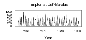
Timpton at Ust'-Baralas
Lena
| PointID: | 6241 |
Code: | 3247 |
Latitude (decimal degrees): | 56.95 |
Longitude (decimal degrees): | 125.45 |
Drainage Area (km2): | 13300.00 |
Source: | SHI |
Hydrological Zone: | Lena |
Name: | Timpton at Ust'-Baralas |
Field Definitions
Site Time Series Plot:
Site Data File:
(Units: m3/s)
| ID | Year | Jan | Feb | Mar | Apr | May | Jun | Jul | Aug | Sep | Oct | Nov | Dec |
|---|
| 6241 | 1955 | 3.08 | 2.46 | 2.01 | 2.02 | 669.00 | 222.00 | 387.00 | 323.00 | 236.00 | 56.00 | 15.60 | 9.00 |
| 6241 | 1956 | 3.79 | 2.90 | 1.98 | 2.07 | 321.00 | 958.00 | 407.00 | 664.00 | 458.00 | 177.00 | 32.70 | 17.20 |
| 6241 | 1957 | 8.13 | 5.33 | 3.18 | 3.52 | 618.00 | 437.00 | 584.00 | | | | | |
| 6241 | 1958 | 3.94 | 2.91 | 2.37 | 3.12 | 507.00 | 229.00 | 985.00 | 133.00 | 469.00 | 204.00 | 51.00 | 24.50 |
| 6241 | 1959 | 12.40 | 8.64 | 7.65 | 9.36 | 651.00 | 465.00 | 639.00 | 734.00 | 524.00 | 137.00 | 38.70 | 17.60 |
| 6241 | 1960 | 8.03 | 5.38 | 4.42 | 5.19 | 500.00 | 340.00 | 208.00 | 506.00 | 311.00 | 64.40 | 26.40 | 12.60 |
| 6241 | 1961 | 4.73 | 3.74 | 3.26 | 4.26 | 407.00 | 559.00 | 471.00 | 208.00 | 313.00 | 128.00 | 31.60 | 15.80 |
| 6241 | 1962 | 7.41 | 5.85 | 3.84 | 4.75 | 654.00 | 334.00 | 285.00 | 200.00 | 192.00 | 57.00 | 13.30 | 5.95 |
| 6241 | 1963 | 2.96 | 2.34 | 1.80 | 3.23 | 343.00 | 1060.00 | 158.00 | 81.30 | 110.00 | 54.10 | 22.10 | 9.26 |
| 6241 | 1964 | 4.70 | 2.98 | 2.42 | 2.51 | 618.00 | 419.00 | 369.00 | 106.00 | 139.00 | 58.30 | 23.30 | 8.64 |
| 6241 | 1965 | 3.76 | 2.42 | 2.35 | 4.16 | 334.00 | 489.00 | 446.00 | 432.00 | 401.00 | 76.60 | 20.40 | 6.63 |
| 6241 | 1966 | 2.53 | 1.71 | 1.46 | 3.24 | 443.00 | 754.00 | 240.00 | 278.00 | 155.00 | 63.40 | 14.50 | 6.01 |
| 6241 | 1967 | 3.25 | 1.84 | 1.55 | 119.00 | 531.00 | 268.00 | 270.00 | 433.00 | 308.00 | 155.00 | 30.70 | 8.26 |
| 6241 | 1968 | 6.11 | 3.06 | 2.57 | 117.00 | 582.00 | 388.00 | 388.00 | 269.00 | 331.00 | 92.90 | 29.60 | 8.60 |
| 6241 | 1969 | 4.38 | 2.76 | 2.04 | 1.96 | 564.00 | 647.00 | 375.00 | 99.30 | 94.50 | 33.40 | 12.40 | 5.04 |
| 6241 | 1970 | 2.89 | 1.79 | 1.48 | 2.84 | 602.00 | 794.00 | 80.30 | 153.00 | 282.00 | 69.50 | 33.70 | 11.60 |
| 6241 | 1971 | 6.70 | 3.66 | 2.18 | 2.19 | 863.00 | 270.00 | 350.00 | 412.00 | 395.00 | 101.00 | 45.00 | 16.30 |
| 6241 | 1972 | 7.14 | 3.27 | 2.63 | 3.00 | 336.00 | 500.00 | 480.00 | 615.00 | 346.00 | 157.00 | 21.00 | 7.46 |
| 6241 | 1973 | 3.51 | 2.91 | 2.59 | 2.29 | 388.00 | 233.00 | 391.00 | 552.00 | 124.00 | 70.10 | 32.40 | 9.84 |
| 6241 | 1974 | 4.73 | 3.10 | 2.54 | 4.34 | 464.00 | 485.00 | 508.00 | 471.00 | 276.00 | 111.00 | 25.50 | 11.50 |
| 6241 | 1975 | 4.91 | 3.57 | 2.85 | 28.30 | 652.00 | 380.00 | 346.00 | 456.00 | 358.00 | 92.80 | 39.80 | 11.70 |
| 6241 | 1976 | 6.00 | 4.43 | 3.58 | 4.82 | 481.00 | 642.00 | 227.00 | 198.00 | 294.00 | 76.50 | 30.40 | 11.50 |
| 6241 | 1977 | 5.27 | 3.38 | 2.55 | 3.48 | 499.00 | 331.00 | 268.00 | 318.00 | 257.00 | 71.50 | 35.10 | 11.90 |
| 6241 | 1978 | 6.73 | 5.54 | 3.94 | 13.70 | 744.00 | 528.00 | 565.00 | 173.00 | 279.00 | 129.00 | 55.50 | 21.90 |
| 6241 | 1979 | 13.80 | 7.88 | 5.22 | 11.50 | 601.00 | 177.00 | 209.00 | 497.00 | 356.00 | 97.80 | 22.70 | 13.70 |
| 6241 | 1980 | 10.50 | 6.03 | 3.64 | 3.93 | 445.00 | 729.00 | 442.00 | 251.00 | 140.00 | 48.00 | 20.80 | 14.90 |
| 6241 | 1981 | 8.33 | 6.13 | 3.86 | 29.40 | 596.00 | 537.00 | 441.00 | 487.00 | 406.00 | 141.00 | 53.60 | 24.10 |
| 6241 | 1982 | 12.60 | 8.14 | 8.79 | 39.20 | 697.00 | 480.00 | 385.00 | 602.00 | 459.00 | 103.00 | 69.00 | 18.70 |
| 6241 | 1983 | 12.70 | 9.98 | 8.17 | 10.30 | 817.00 | 700.00 | 364.00 | 223.00 | 371.00 | 153.00 | 151.00 | 55.10 |
| 6241 | 1984 | 18.70 | 11.40 | 9.61 | 25.90 | 793.00 | 447.00 | 224.00 | 171.00 | 112.00 | 62.80 | 30.60 | 11.60 |
| 6241 | 1985 | 7.71 | 3.99 | 3.28 | 56.70 | 458.00 | 349.00 | 261.00 | 227.00 | 288.00 | 89.20 | 39.60 | 15.40 |
| 6241 | 1986 | 9.26 | 4.86 | 3.67 | 6.31 | 384.00 | 316.00 | 191.00 | 297.00 | 104.00 | 65.50 | 11.90 | 7.70 |
| 6241 | 1987 | 5.30 | 3.86 | 3.27 | 3.78 | 266.00 | 757.00 | 530.00 | 245.00 | 196.00 | 71.20 | 20.70 | 12.10 |
| 6241 | 1988 | 9.20 | 5.20 | 3.03 | 62.40 | 617.00 | 578.00 | 395.00 | 368.00 | 310.00 | 119.00 | 58.50 | 16.50 |
| 6241 | 1989 | 9.99 | 7.42 | 6.05 | 25.00 | 475.00 | 593.00 | 399.00 | 357.00 | 267.00 | 138.00 | 83.60 | 27.60 |
| 6241 | 1990 | 12.90 | 8.43 | 5.35 | 14.80 | 503.00 | 274.00 | 349.00 | 148.00 | 238.00 | 85.20 | 43.00 | 18.10 |
 Return to R-Arctic Net Home Page