| PointID: | 623 | Code: | 07AF014 | Latitude (decimal degrees): | 53.37 | Longitude (decimal degrees): | -116.80 | Drainage Area (km2): | 647.00 | Source: | Hydat | Hydrological Zone: | Mackenzie | Name: | EMBARRAS RIVER NEAR WEALD |
|---|
| Download | |
|---|---|
| Site Descriptor Information | Site Time Series Data |
| Link to all available data | |
| ID | Year | Jan | Feb | Mar | Apr | May | Jun | Jul | Aug | Sep | Oct | Nov | Dec |
|---|---|---|---|---|---|---|---|---|---|---|---|---|---|
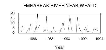
| 623 | 1984 | 0.98 | 6.99 | 4.80 | |||||||||
| 623 | 1985 | 0.00 | 2.00 | 2.56 | 4.04 | 2.19 | 5.15 | 8.24 | 4.16 | ||||
| 623 | 1986 | 1.00 | 3.00 | 7.41 | 3.93 | 19.30 | 4.73 | 6.12 | 7.60 | ||||
| 623 | 1987 | 0.00 | 1.00 | 2.66 | 1.42 | 1.73 | 16.90 | 3.03 | 1.88 | ||||
| 623 | 1988 | 0.00 | 2.00 | 1.53 | 5.33 | 1.85 | 1.56 | 1.24 | 1.13 | ||||
| 623 | 1989 | 0.00 | 1.00 | 3.75 | 3.37 | 8.51 | 11.20 | 6.79 | 3.33 | ||||
| 623 | 1990 | 1.00 | 4.00 | 10.80 | 16.70 | 11.80 | 3.52 | 2.86 | 2.22 | ||||
| 623 | 1991 | 0.00 | 8.00 | 15.80 | 7.09 | 6.43 | 3.68 | 2.16 | 1.56 | ||||
| 623 | 1992 | 3.00 | 5.00 | 5.34 | 2.85 | 1.44 | 0.80 | 1.13 | 0.93 | ||||
| 623 | 1993 | 0.00 | 3.00 | 2.71 | 2.74 | 2.93 | 3.58 | 3.33 | 1.81 |
 Return to R-Arctic Net Home Page