Kalar at Katugino
Lena
| PointID: | 6186 |
Code: | 3123 |
Latitude (decimal degrees): | 56.05 |
Longitude (decimal degrees): | 119.12 |
Drainage Area (km2): | 7980.00 |
Source: | SHI |
Hydrological Zone: | Lena |
Name: | Kalar at Katugino |
Field Definitions
Site Time Series Plot:
Site Data File:
(Units: m3/s)
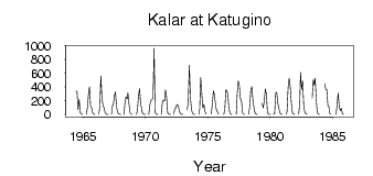
| ID | Year | Jan | Feb | Mar | Apr | May | Jun | Jul | Aug | Sep | Oct | Nov | Dec |
|---|
| 6186 | 1964 | | | | | | 338.00 | 337.00 | 64.60 | 221.00 | 27.60 | 9.01 | 2.80 |
| 6186 | 1965 | | | | 0.87 | 95.20 | 286.00 | 401.00 | 127.00 | 96.10 | 24.20 | 5.39 | 2.10 |
| 6186 | 1966 | | | | 0.02 | 110.00 | 563.00 | 246.00 | 133.00 | 93.70 | 27.70 | 5.77 | 1.93 |
| 6186 | 1967 | 0.19 | | | 3.12 | 133.00 | 134.00 | 275.00 | 326.00 | 121.00 | 33.80 | 5.05 | 3.25 |
| 6186 | 1968 | 0.52 | | | 0.12 | 174.00 | 257.00 | 225.00 | 315.00 | 159.00 | 20.90 | 5.53 | 2.10 |
| 6186 | 1969 | | | | 0.34 | 54.10 | 261.00 | 376.00 | 171.00 | 77.60 | 19.60 | 5.31 | 1.59 |
| 6186 | 1970 | 0.09 | | | 0.53 | 139.00 | 210.00 | 209.00 | 260.00 | 962.00 | 26.40 | 3.99 | 0.78 |
| 6186 | 1971 | 4.0e-03 | | | 1.60 | 165.00 | 208.00 | 194.00 | 358.00 | 257.00 | 28.10 | 6.55 | 1.25 |
| 6186 | 1972 | 2.0e-03 | | | 0.88 | 80.30 | 99.00 | 145.00 | 134.00 | 78.30 | 19.80 | 3.42 | 0.72 |
| 6186 | 1973 | 1.0e-03 | | | | 66.20 | 194.00 | 715.00 | 256.00 | 70.10 | 17.50 | 4.82 | 0.63 |
| 6186 | 1974 | | | | 0.44 | 72.40 | 540.00 | 308.00 | 94.60 | 148.00 | 46.40 | 5.44 | |
| 6186 | 1975 | | | | 5.74 | 165.00 | 341.00 | 302.00 | 179.00 | 71.70 | 41.50 | 5.98 | |
| 6186 | 1976 | | | | 0.53 | 73.30 | 359.00 | 346.00 | 274.00 | 107.00 | 22.40 | 5.39 | 0.53 |
| 6186 | 1977 | | | | 0.93 | 314.00 | 487.00 | 416.00 | 228.00 | 189.00 | 21.20 | 3.16 | 0.16 |
| 6186 | 1978 | | | | 0.42 | 114.00 | 362.00 | 403.00 | 203.00 | 102.00 | 24.80 | 5.91 | 0.36 |
| 6186 | 1979 | | | | | 162.00 | 92.50 | 203.00 | 372.00 | 296.00 | 27.00 | 5.92 | 1.03 |
| 6186 | 1980 | 0.02 | | | 0.75 | 11.00 | 313.00 | 325.00 | 163.00 | 96.40 | 25.60 | 5.42 | 0.36 |
| 6186 | 1981 | | | | 0.60 | 46.10 | 390.00 | 526.00 | 407.00 | 169.00 | 31.70 | 5.65 | 1.11 |
| 6186 | 1982 | | | | 2.68 | 181.00 | 613.00 | 366.00 | 485.00 | 121.00 | 30.40 | 8.66 | 1.14 |
| 6186 | 1983 | | | | | 238.00 | 503.00 | 427.00 | 528.00 | 222.00 | 25.10 | 6.15 | 0.93 |
| 6186 | 1984 | | | | | 452.00 | 364.00 | 363.00 | 135.00 | 111.00 | 15.20 | 5.57 | |
| 6186 | 1985 | | | | 1.24 | 143.00 | 313.00 | 116.00 | 53.30 | 88.30 | 9.63 | 1.24 | |
 Return to R-Arctic Net Home Page