Kunerma at Kunerma
Lena
| PointID: | 6166 |
Code: | 3088 |
Latitude (decimal degrees): | 55.77 |
Longitude (decimal degrees): | 108.47 |
Drainage Area (km2): | 528.00 |
Source: | SHI |
Hydrological Zone: | Lena |
Name: | Kunerma at Kunerma |
Field Definitions
Site Time Series Plot:
Site Data File:
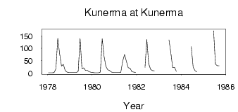
(Units: m3/s)
| ID | Year | Jan | Feb | Mar | Apr | May | Jun | Jul | Aug | Sep | Oct | Nov | Dec |
|---|
| 6166 | 1978 | 1.20 | 0.97 | 1.29 | 2.00 | 17.30 | 140.00 | 78.30 | 28.40 | 35.20 | 10.10 | 4.18 | 1.97 |
| 6166 | 1979 | 1.67 | 1.81 | 1.76 | 1.73 | 8.24 | 140.00 | 18.70 | 21.10 | 10.40 | 10.40 | 5.59 | 3.33 |
| 6166 | 1980 | 1.74 | 1.10 | 1.04 | 1.21 | 4.23 | 139.00 | 67.50 | 26.20 | 13.60 | 9.83 | 3.56 | 2.60 |
| 6166 | 1981 | 2.42 | 2.25 | 2.30 | 3.29 | 48.30 | 74.90 | 48.10 | 21.40 | 19.30 | 5.55 | 3.72 | 2.32 |
| 6166 | 1982 | | | | | 22.20 | 136.00 | 37.70 | 15.70 | 10.20 | 9.24 | | |
| 6166 | 1983 | | | | | | 134.00 | 82.20 | 21.80 | 23.20 | 6.53 | | |
| 6166 | 1984 | | | | | | 107.00 | 24.40 | 10.00 | 4.58 | | | |
| 6166 | 1985 | | | | | | 171.00 | 35.90 | 29.60 | 29.60 | | | |
 Return to R-Arctic Net Home Page