Lena at Ust'-Kut
Lena
| PointID: | 6141 |
Code: | 3010 |
Latitude (decimal degrees): | 56.77 |
Longitude (decimal degrees): | 105.65 |
Drainage Area (km2): | 71400.00 |
Source: | SHI |
Hydrological Zone: | Lena |
Name: | Lena at Ust'-Kut |
Field Definitions
Site Time Series Plot:
Site Data File:
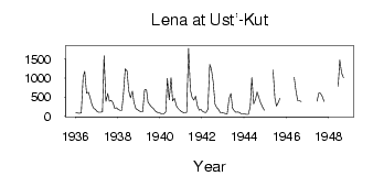
(Units: m3/s)
| ID | Year | Jan | Feb | Mar | Apr | May | Jun | Jul | Aug | Sep | Oct | Nov | Dec |
|---|
| 6141 | 1936 | 84.00 | 73.70 | 71.00 | 79.60 | 1030.00 | 1180.00 | 600.00 | 624.00 | 497.00 | 309.00 | 206.00 | 171.00 |
| 6141 | 1937 | 117.00 | 97.30 | 93.90 | 113.00 | 1600.00 | 382.00 | 589.00 | 393.00 | 412.00 | 348.00 | 199.00 | 215.00 |
| 6141 | 1938 | 171.00 | 149.00 | 149.00 | 565.00 | 1250.00 | 1190.00 | 672.00 | 479.00 | 658.00 | 356.00 | 192.00 | 167.00 |
| 6141 | 1939 | 128.00 | 111.00 | 110.00 | 693.00 | 694.00 | 360.00 | 292.00 | 230.00 | 200.00 | 128.00 | 97.10 | 87.50 |
| 6141 | 1940 | 69.20 | 57.00 | 52.40 | 112.00 | 992.00 | 427.00 | 1010.00 | 400.00 | 468.00 | 269.00 | 199.00 | 154.00 |
| 6141 | 1941 | 110.00 | 86.80 | 79.00 | 94.20 | 1790.00 | 690.00 | 504.00 | 421.00 | 523.00 | 276.00 | 155.00 | 170.00 |
| 6141 | 1942 | 114.00 | 93.50 | 87.30 | 174.00 | 1360.00 | 1250.00 | 908.00 | 315.00 | 229.00 | 171.00 | 81.60 | 80.90 |
| 6141 | 1943 | 71.80 | 59.00 | 53.90 | 461.00 | 594.00 | 211.00 | 129.00 | 97.00 | 103.00 | 85.80 | 56.00 | 50.50 |
| 6141 | 1944 | 45.80 | 39.70 | 37.80 | 241.00 | 1010.00 | 319.00 | 440.00 | 633.00 | 480.00 | 348.00 | 242.00 | 154.00 |
| 6141 | 1945 | | | | | 1220.00 | 472.00 | 258.00 | 355.00 | 468.00 | | | |
| 6141 | 1946 | | | | | 1020.00 | 688.00 | 402.00 | 406.00 | 383.00 | | | |
| 6141 | 1947 | | | | | | 390.00 | 607.00 | 600.00 | 516.00 | 383.00 | | |
| 6141 | 1948 | | | | | | 778.00 | 1480.00 | 1140.00 | 1010.00 | | | |
 Return to R-Arctic Net Home Page