Lena at Zjigalovo
Lena
| PointID: | 6138 |
Code: | 3004 |
Latitude (decimal degrees): | 54.82 |
Longitude (decimal degrees): | 105.13 |
Drainage Area (km2): | 30400.00 |
Source: | SHI |
Hydrological Zone: | Lena |
Name: | Lena at Zjigalovo |
Field Definitions
Site Time Series Plot:
Site Data File:
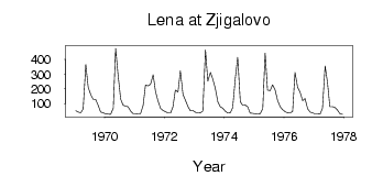
(Units: m3/s)
| ID | Year | Jan | Feb | Mar | Apr | May | Jun | Jul | Aug | Sep | Oct | Nov | Dec |
|---|
| 6138 | 1969 | 52.10 | 43.00 | 38.30 | 65.00 | 366.00 | 212.00 | 159.00 | 130.00 | 129.00 | 88.40 | 42.60 | 38.90 |
| 6138 | 1970 | 31.40 | 28.70 | 26.80 | 70.60 | 475.00 | 297.00 | 131.00 | 89.60 | 83.40 | 79.40 | 48.60 | 32.80 |
| 6138 | 1971 | 32.20 | 30.50 | 30.80 | 88.00 | 225.00 | 220.00 | 231.00 | 295.00 | 182.00 | 120.00 | 68.50 | 53.40 |
| 6138 | 1972 | 44.80 | 37.00 | 37.00 | 78.40 | 191.00 | 179.00 | 322.00 | 161.00 | 124.00 | 79.80 | 52.20 | 53.50 |
| 6138 | 1973 | 40.90 | 36.50 | 37.70 | 50.00 | 463.00 | 253.00 | 311.00 | 266.00 | 207.00 | 111.00 | 80.00 | 68.10 |
| 6138 | 1974 | 49.20 | 35.60 | 38.20 | 72.00 | 270.00 | 413.00 | 114.00 | 87.70 | 89.80 | 78.60 | 36.10 | 35.20 |
| 6138 | 1975 | 31.80 | 28.80 | 31.40 | 66.60 | 443.00 | 191.00 | 188.00 | 228.00 | 192.00 | 122.00 | 79.00 | 59.00 |
| 6138 | 1976 | 45.20 | 37.40 | 35.80 | 47.30 | 312.00 | 210.00 | 179.00 | 121.00 | 135.00 | 64.10 | 43.70 | 37.40 |
| 6138 | 1977 | 30.90 | 30.10 | 29.30 | 68.20 | 355.00 | 244.00 | 79.40 | 78.70 | 76.20 | 56.00 | 33.40 | 27.00 |
 Return to R-Arctic Net Home Page