| PointID: | 605 | Code: | 07AD007 | Latitude (decimal degrees): | 53.39 | Longitude (decimal degrees): | -117.48 | Drainage Area (km2): | 2.72 | Source: | Hydat | Hydrological Zone: | Mackenzie | Name: | CACHE PERCOTTE CREEK (NORTH FORK) NEAR HINTON |
|---|
| Download | |
|---|---|
| Site Descriptor Information | Site Time Series Data |
| Link to all available data | |
| ID | Year | Jan | Feb | Mar | Apr | May | Jun | Jul | Aug | Sep | Oct | Nov | Dec |
|---|---|---|---|---|---|---|---|---|---|---|---|---|---|
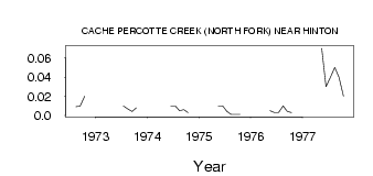
| 605 | 1972 | 9.0e-03 | 0.01 | 0.02 | |||||||||
| 605 | 1973 | 0.01 | 7.0e-03 | 4.0e-03 | 8.0e-03 | ||||||||
| 605 | 1974 | 0.01 | 0.01 | 5.0e-03 | 6.0e-03 | 3.0e-03 | |||||||
| 605 | 1975 | 0.01 | 0.01 | 4.0e-03 | 1.0e-03 | 1.0e-03 | 1.0e-03 | ||||||
| 605 | 1976 | 5.0e-03 | 3.0e-03 | 3.0e-03 | 0.01 | 4.0e-03 | 3.0e-03 | ||||||
| 605 | 1977 | 0.07 | 0.03 | 0.04 | 0.05 | 0.04 | 0.02 |
 Return to R-Arctic Net Home Page