| PointID: | 600 | Code: | 07AD002 | Latitude (decimal degrees): | 53.41 | Longitude (decimal degrees): | -117.58 | Drainage Area (km2): | 9780.00 | Source: | Hydat | Hydrological Zone: | Mackenzie | Name: | ATHABASCA RIVER AT HINTON |
|---|
| Download | |
|---|---|
| Site Descriptor Information | Site Time Series Data |
| Link to all available data | |
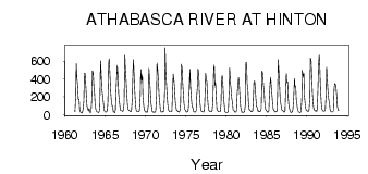
| ID | Year | Jan | Feb | Mar | Apr | May | Jun | Jul | Aug | Sep | Oct | Nov | Dec |
|---|---|---|---|---|---|---|---|---|---|---|---|---|---|
| 600 | 1961 | 31.00 | 215.00 | 574.00 | 402.00 | 338.00 | 171.00 | 172.00 | 61.00 | 31.00 | |||
| 600 | 1962 | 22.00 | 18.00 | 19.00 | 57.00 | 154.00 | 465.00 | 463.00 | 350.00 | 200.00 | 95.90 | 63.00 | 40.00 |
| 600 | 1963 | 68.00 | 46.00 | 16.00 | 51.00 | 156.00 | 493.00 | 464.00 | 329.00 | 233.00 | 117.00 | 56.00 | 41.00 |
| 600 | 1964 | 30.00 | 30.00 | 24.00 | 36.00 | 96.20 | 603.00 | 497.00 | 283.00 | 216.00 | 161.00 | 74.00 | 40.00 |
| 600 | 1965 | 28.00 | 28.00 | 31.00 | 49.00 | 147.00 | 573.00 | 628.00 | 445.00 | 243.00 | 167.00 | 98.00 | 100.00 |
| 600 | 1966 | 33.00 | 32.00 | 21.00 | 49.00 | 238.00 | 435.00 | 553.00 | 413.00 | 238.00 | 146.00 | 66.00 | 46.00 |
| 600 | 1967 | 46.00 | 42.00 | 36.00 | 47.00 | 124.00 | 670.00 | 524.00 | 382.00 | 257.00 | 120.00 | 60.00 | 48.00 |
| 600 | 1968 | 43.00 | 36.00 | 41.00 | 34.00 | 164.00 | 498.00 | 620.00 | 386.00 | 255.00 | 106.00 | 54.00 | 36.00 |
| 600 | 1969 | 35.00 | 32.00 | 35.00 | 50.00 | 212.00 | 507.00 | 385.00 | 448.00 | 196.00 | 101.00 | 62.00 | 38.00 |
| 600 | 1970 | 30.00 | 33.00 | 26.00 | 31.00 | 110.00 | 521.00 | 382.00 | 286.00 | 132.00 | 69.60 | 34.00 | 30.00 |
| 600 | 1971 | 24.00 | 31.00 | 27.00 | 40.00 | 213.00 | 581.00 | 497.00 | 393.00 | 215.00 | 116.00 | 48.00 | 29.00 |
| 600 | 1972 | 33.00 | 30.00 | 41.00 | 36.00 | 218.00 | 752.00 | 459.00 | 353.00 | 199.00 | 118.00 | 52.00 | 35.00 |
| 600 | 1973 | 32.00 | 32.00 | 35.00 | 38.00 | 201.00 | 457.00 | 384.00 | 310.00 | 153.00 | 100.00 | 46.00 | 45.00 |
| 600 | 1974 | 36.00 | 31.00 | 30.00 | 48.00 | 123.00 | 565.00 | 532.00 | 370.00 | 234.00 | 131.00 | 62.00 | 52.00 |
| 600 | 1975 | 34.00 | 29.00 | 32.00 | 38.00 | 101.00 | 347.00 | 511.00 | 278.00 | 157.00 | 90.50 | 80.00 | 42.00 |
| 600 | 1976 | 30.00 | 32.00 | 29.00 | 43.00 | 207.00 | 321.00 | 513.00 | 469.00 | 264.00 | 119.00 | 49.00 | 38.00 |
| 600 | 1977 | 34.00 | 33.00 | 30.00 | 42.00 | 166.00 | 466.00 | 417.00 | 365.00 | 208.00 | 92.60 | 39.00 | 39.00 |
| 600 | 1978 | 33.00 | 31.00 | 34.00 | 43.00 | 138.00 | 515.00 | 558.00 | 324.00 | 359.00 | 166.00 | 62.00 | 44.00 |
| 600 | 1979 | 34.00 | 32.00 | 33.00 | 35.00 | 121.00 | 417.00 | 440.00 | 300.00 | 185.00 | 95.70 | 35.00 | 25.00 |
| 600 | 1980 | 22.00 | 26.00 | 27.00 | 57.00 | 266.00 | 526.00 | 352.00 | 269.00 | 182.00 | 134.00 | 55.00 | 48.00 |
| 600 | 1981 | 39.00 | 26.00 | 32.00 | 38.00 | 235.00 | 308.00 | 416.00 | 370.00 | 205.00 | 79.40 | 55.00 | 24.00 |
| 600 | 1982 | 30.00 | 27.00 | 27.00 | 36.00 | 108.00 | 584.00 | 589.00 | 350.00 | 281.00 | 145.00 | 59.00 | 47.00 |
| 600 | 1983 | 42.00 | 33.00 | 34.00 | 39.00 | 138.00 | 374.00 | 374.00 | 286.00 | 158.00 | 93.10 | 75.00 | 34.00 |
| 600 | 1984 | 43.00 | 31.00 | 33.00 | 42.00 | 66.40 | 489.00 | 461.00 | 341.00 | 267.00 | 147.00 | 66.00 | 45.00 |
| 600 | 1985 | 39.00 | 25.00 | 29.00 | 39.00 | 205.00 | 360.00 | 415.00 | 294.00 | 187.00 | 94.80 | 48.00 | 42.00 |
| 600 | 1986 | 37.00 | 29.00 | 37.00 | 37.00 | 195.00 | 620.00 | 505.00 | 325.00 | 193.00 | 116.00 | 61.00 | 45.00 |
| 600 | 1987 | 44.00 | 32.00 | 28.00 | 38.00 | 222.00 | 462.00 | 359.00 | 370.00 | 187.00 | 88.80 | 55.00 | 33.00 |
| 600 | 1988 | 23.00 | 28.00 | 28.00 | 57.00 | 191.00 | 404.00 | 316.00 | 316.00 | 176.00 | 109.00 | 60.00 | 35.00 |
| 600 | 1989 | 27.00 | 25.00 | 24.00 | 40.00 | 165.00 | 499.00 | 429.00 | 462.00 | 220.00 | 118.00 | 69.00 | 43.00 |
| 600 | 1990 | 42.00 | 36.00 | 36.00 | 51.00 | 189.00 | 638.00 | 607.00 | 384.00 | 232.00 | 111.00 | 65.00 | 48.00 |
| 600 | 1991 | 41.00 | 45.00 | 36.00 | 60.00 | 293.00 | 549.00 | 672.00 | 544.00 | 268.00 | 124.00 | 64.00 | 42.00 |
| 600 | 1992 | 40.00 | 37.00 | 41.00 | 55.00 | 229.00 | 534.00 | 372.00 | 274.00 | 169.00 | 134.00 | 62.00 | 36.00 |
| 600 | 1993 | 34.00 | 28.00 | 31.00 | 40.00 | 290.00 | 348.00 | 340.00 | 315.00 | 201.00 | 96.70 | 46.00 | 45.00 |
 Return to R-Arctic Net Home Page