KOLYMA - KOLYMSKOYE
Anadyr Kolyma
| PointID: | 5952 |
Code: | 1802 |
Latitude (decimal degrees): | 68.73 |
Longitude (decimal degrees): | 158.72 |
Drainage Area (km2): | 526000.00 |
Source: | SHI |
Hydrological Zone: | Anadyr Kolyma |
Name: | KOLYMA - KOLYMSKOYE |
Field Definitions
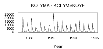
Site Time Series Plot:
Site Data File:
(Units: m3/s)
| ID | Year | Jan | Feb | Mar | Apr | May | Jun | Jul | Aug | Sep | Oct | Nov | Dec |
|---|
| 5952 | 1978 | 202.00 | 83.80 | 66.50 | 51.70 | 380.00 | 20948.00 | 17655.00 | 8687.00 | 4961.00 | 1058.00 | 318.00 | 240.00 |
| 5952 | 1979 | 156.00 | 58.50 | 43.50 | 30.60 | 1591.00 | 13905.00 | 9531.00 | 6463.00 | 4628.00 | 1822.00 | 294.00 | 199.00 |
| 5952 | 1980 | 144.00 | 83.70 | 67.70 | 43.20 | 487.00 | 19037.00 | 14632.00 | 6714.00 | 2995.00 | 1752.00 | 417.00 | 217.00 |
| 5952 | 1981 | 136.00 | 130.00 | 79.70 | 100.00 | 2708.00 | 11251.00 | 4749.00 | 5563.00 | 3272.00 | 1561.00 | 383.00 | 289.00 |
| 5952 | 1982 | 181.00 | 109.00 | 93.50 | 81.90 | 1279.00 | 13435.00 | 6447.00 | 5080.00 | 6363.00 | 1350.00 | 369.00 | 390.00 |
| 5952 | 1983 | 280.00 | 154.00 | 105.00 | 91.00 | 1266.00 | 8180.00 | 3409.00 | 4220.00 | 3147.00 | 942.00 | 340.00 | 210.00 |
| 5952 | 1984 | 127.00 | 161.00 | 152.00 | 94.80 | 3501.00 | 7390.00 | 9248.00 | 8599.00 | 5823.00 | 1838.00 | 597.00 | 370.00 |
| 5952 | 1985 | 267.00 | 177.00 | 163.00 | 140.00 | 295.00 | 26201.00 | 14043.00 | 9078.00 | 5464.00 | 1860.00 | 422.00 | 342.00 |
| 5952 | 1986 | 275.00 | 216.00 | 234.00 | 153.00 | 1611.00 | 15847.00 | 6365.00 | 6791.00 | 7829.00 | 3228.00 | 526.00 | 389.00 |
| 5952 | 1987 | 229.00 | 234.00 | 209.00 | 164.00 | 141.00 | 17566.00 | 9578.00 | 4220.00 | 4927.00 | 1591.00 | 396.00 | 259.00 |
| 5952 | 1988 | 184.00 | 143.00 | 100.00 | 100.00 | 590.00 | 9595.00 | 4676.00 | 5786.00 | 4490.00 | 1494.00 | 339.00 | 343.00 |
| 5952 | 1989 | 326.00 | 200.00 | 252.00 | 259.00 | 896.00 | 12283.00 | 3897.00 | 6214.00 | 3396.00 | 1752.00 | 520.00 | 463.00 |
| 5952 | 1990 | 368.00 | 337.00 | 328.00 | 295.00 | 4183.00 | 13058.00 | 7640.00 | 11787.00 | 10271.00 | 2277.00 | 681.00 | 514.00 |
| 5952 | 1991 | 372.00 | 291.00 | 338.00 | 335.00 | 1159.00 | 16076.00 | 3254.00 | 2020.00 | 3067.00 | 1135.00 | 549.00 | 522.00 |
| 5952 | 1992 | 555.00 | 486.00 | 483.00 | 405.00 | 3593.00 | 12788.00 | 5654.00 | 2314.00 | 2260.00 | 1104.00 | 474.00 | 417.00 |
| 5952 | 1993 | 341.00 | 330.00 | 323.00 | 289.00 | 1500.00 | 12563.00 | 4382.00 | 4709.00 | 5342.00 | 1388.00 | 496.00 | 344.00 |
| 5952 | 1994 | 295.00 | 213.00 | 215.00 | 175.00 | 2934.00 | 13020.00 | 3608.00 | 4118.00 | 5137.00 | 2283.00 | 440.00 | 303.00 |
 Return to R-Arctic Net Home Page