Yeropol at Chuvanskoje
Anadyr Kolyma
| PointID: | 5947 |
Code: | 1605 |
Latitude (decimal degrees): | 65.20 |
Longitude (decimal degrees): | 168.22 |
Drainage Area (km2): | 8360.00 |
Source: | SHI |
Hydrological Zone: | Anadyr Kolyma |
Name: | Yeropol at Chuvanskoje |
Field Definitions
Site Time Series Plot:
Site Data File:
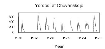
(Units: m3/s)
| ID | Year | Jan | Feb | Mar | Apr | May | Jun | Jul | Aug | Sep | Oct | Nov | Dec |
|---|
| 5947 | 1976 | | | | | 14.40 | 477.00 | 137.00 | 105.00 | 54.30 | 10.50 | | |
| 5947 | 1978 | | | | | 75.00 | 730.00 | 466.00 | 299.00 | 259.00 | 60.00 | | |
| 5947 | 1979 | | | | | 89.90 | 667.00 | 282.00 | 254.00 | 280.00 | 75.00 | | |
| 5947 | 1980 | | | | | 114.00 | 567.00 | 541.00 | 97.90 | 35.20 | 9.50 | | |
| 5947 | 1981 | | | | | 28.50 | 380.00 | 95.30 | 35.40 | 53.90 | 18.50 | | |
| 5947 | 1982 | | | | | | 521.00 | 287.00 | 182.00 | 143.00 | 56.50 | | |
| 5947 | 1983 | | | | | 53.30 | 507.00 | 221.00 | 258.00 | 104.00 | 27.20 | | |
| 5947 | 1984 | | | | | 130.00 | 418.00 | 232.00 | 267.00 | 369.00 | 106.00 | | |
| 5947 | 1985 | | | | | 4.36 | 676.00 | 505.00 | 326.00 | 122.00 | 23.80 | | |
 Return to R-Arctic Net Home Page