Burlivaya at Ust'e
Anadyr Kolyma
| PointID: | 5945 |
Code: | 1598 |
Latitude (decimal degrees): | 61.78 |
Longitude (decimal degrees): | 149.83 |
Drainage Area (km2): | 71.40 |
Source: | SHI |
Hydrological Zone: | Anadyr Kolyma |
Name: | Burlivaya at Ust'e |
Field Definitions
Site Time Series Plot:
Site Data File:
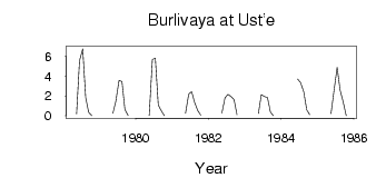
(Units: m3/s)
| ID | Year | Jan | Feb | Mar | Apr | May | Jun | Jul | Aug | Sep | Oct | Nov | Dec |
|---|
| 5945 | 1978 | | | | | 0.21 | 5.54 | 6.74 | 1.86 | 0.37 | 3.0e-03 | | |
| 5945 | 1979 | | | | | 0.25 | 1.45 | 3.55 | 3.45 | 0.64 | 0.03 | | |
| 5945 | 1980 | | | | | 0.04 | 5.67 | 5.79 | 1.08 | 0.48 | 0.02 | | |
| 5945 | 1981 | | | | | 0.24 | 2.18 | 2.43 | 1.35 | 0.52 | 0.07 | | |
| 5945 | 1982 | | | | | 0.25 | 1.80 | 2.15 | 1.96 | 1.63 | 0.08 | | |
| 5945 | 1983 | | | | | 0.22 | 2.14 | 1.96 | 1.84 | 0.38 | 0.02 | | |
| 5945 | 1984 | | | | | | 3.69 | 3.34 | 2.41 | 0.61 | 0.13 | | |
| 5945 | 1985 | | | | | 0.22 | 2.48 | 4.87 | 2.60 | 1.46 | 5.0e-03 | | |
 Return to R-Arctic Net Home Page