Anadyr at Bazakrepost
Anadyr Kolyma
| PointID: | 5940 |
Code: | 1590 |
Latitude (decimal degrees): | 64.75 |
Longitude (decimal degrees): | 170.75 |
Drainage Area (km2): | 55100.00 |
Source: | SHI |
Hydrological Zone: | Anadyr Kolyma |
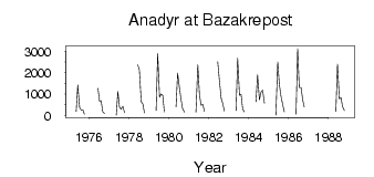
Name: | Anadyr at Bazakrepost |
Field Definitions
Site Time Series Plot:
Site Data File:
(Units: m3/s)
| ID | Year | Jan | Feb | Mar | Apr | May | Jun | Jul | Aug | Sep | Oct | Nov | Dec |
|---|
| 5940 | 1975 | | | | | 183.00 | 1420.00 | 367.00 | 250.00 | 274.00 | 56.80 | | |
| 5940 | 1976 | | | | | | 1270.00 | 665.00 | 689.00 | 173.00 | 95.90 | | |
| 5940 | 1977 | | | | | 20.30 | 1130.00 | 397.00 | 289.00 | 426.00 | 135.00 | | |
| 5940 | 1978 | | | | | | 2370.00 | 2130.00 | 642.00 | 546.00 | 121.00 | | |
| 5940 | 1979 | | | | | 229.00 | 2900.00 | 854.00 | 1000.00 | 933.00 | 163.00 | | |
| 5940 | 1980 | | | | | 399.00 | 1980.00 | 1290.00 | 743.00 | 309.00 | 159.00 | | |
| 5940 | 1981 | | | | | 157.00 | 2370.00 | 1030.00 | 475.00 | 520.00 | 193.00 | | |
| 5940 | 1982 | | | | | | 2520.00 | 1680.00 | 798.00 | 553.00 | 208.00 | | |
| 5940 | 1983 | | | | | 228.00 | 2680.00 | 943.00 | 991.00 | 304.00 | 165.00 | | |
| 5940 | 1984 | | | | | 644.00 | 1910.00 | 732.00 | 1090.00 | 1190.00 | 572.00 | | |
| 5940 | 1985 | | | | | 15.80 | 2500.00 | 1460.00 | 909.00 | 486.00 | 172.00 | | |
| 5940 | 1986 | | | | | 62.00 | 3130.00 | 1310.00 | 1300.00 | 722.00 | 398.00 | | |
| 5940 | 1988 | | | | | 189.00 | 2410.00 | 773.00 | 846.00 | 423.00 | 227.00 | | |
 Return to R-Arctic Net Home Page