Main at Vaegi
Anadyr Kolyma
| PointID: | 5921 |
Code: | 1504 |
Latitude (decimal degrees): | 64.17 |
Longitude (decimal degrees): | 171.03 |
Drainage Area (km2): | 18600.00 |
Source: | SHI |
Hydrological Zone: | Anadyr Kolyma |
Name: | Main at Vaegi |
Field Definitions
Site Time Series Plot:
Site Data File:
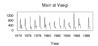
(Units: m3/s)
| ID | Year | Jan | Feb | Mar | Apr | May | Jun | Jul | Aug | Sep | Oct | Nov | Dec |
|---|
| 5921 | 1974 | | | | | 174.00 | 933.00 | 140.00 | 129.00 | 441.00 | 88.80 | | |
| 5921 | 1975 | | | | | 304.00 | 974.00 | 158.00 | 89.00 | 128.00 | 36.60 | | |
| 5921 | 1976 | | | | | | 1130.00 | 101.00 | 306.00 | 141.00 | 48.10 | | |
| 5921 | 1977 | | | | | 69.00 | 864.00 | 273.00 | 235.00 | 371.00 | 115.00 | | |
| 5921 | 1978 | | | | | 250.00 | 1210.00 | 758.00 | 173.00 | 179.00 | 85.50 | | |
| 5921 | 1979 | | | | | 178.00 | 1090.00 | 226.00 | 443.00 | 450.00 | 56.60 | | |
| 5921 | 1980 | | | | | 376.00 | 627.00 | 298.00 | 237.00 | 107.00 | | | |
| 5921 | 1981 | | | | | 270.00 | 740.00 | 191.00 | 263.00 | 174.00 | 121.00 | | |
| 5921 | 1982 | | | | | | 1050.00 | 382.00 | 280.00 | 346.00 | 96.50 | | |
| 5921 | 1983 | | | | | 151.00 | 920.00 | 338.00 | 301.00 | 153.00 | 70.20 | | |
| 5921 | 1984 | | | | | 340.00 | 639.00 | 237.00 | 308.00 | 340.00 | 116.00 | | |
| 5921 | 1985 | | | | | 40.30 | 1430.00 | 259.00 | 217.00 | 280.00 | 23.10 | | |
| 5921 | 1986 | | | | | 219.00 | 986.00 | 387.00 | 511.00 | 506.00 | 169.00 | | |
| 5921 | 1988 | | | | | 62.60 | 1070.00 | 290.00 | 283.00 | 198.00 | 120.00 | | |
 Return to R-Arctic Net Home Page